The Vienna Basin Pilot Area
The Vienna Basin pilot area – a region of growing energy demand
Located at the north-eastern part of the Transenergy region the Vienna Basin pilot area is shared by the involved countries Austria and Slovakia offering home for more than 2 million habitants. It is a region of different socio-economic situations. On the one hand, there is the still growing urban agglomeration zone between the capital cities of Vienna and Bratislava – a region of growing economic importance, the so called “Centrope Region”. On the other hand the vast majority of the affected region is dominated by rural zones showing comprising villages and small cities.
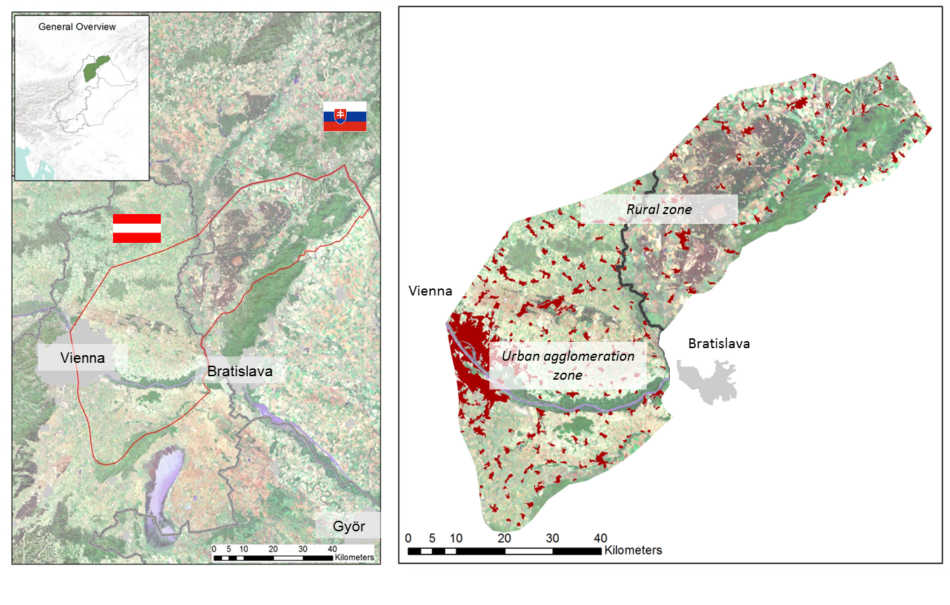
Figure 1: Geographical overview on the Vienna Basin pilot area considering settlement
Irrespective of the different socio-economic framework the Vienna Basin is affected by an increasing demand for energy: Housing and industrial facilities at the urban agglomeration zones as well as agricultural utilizations at the rural zones. The increasing environmental conscience as well as the increasing volatility associated to the price of fossil energy puts a gaining focus on renewable, low-emission as well as local energy sources – such like geothermal energy!
Is the Vienna Basin suitable for the use of geothermal energy?
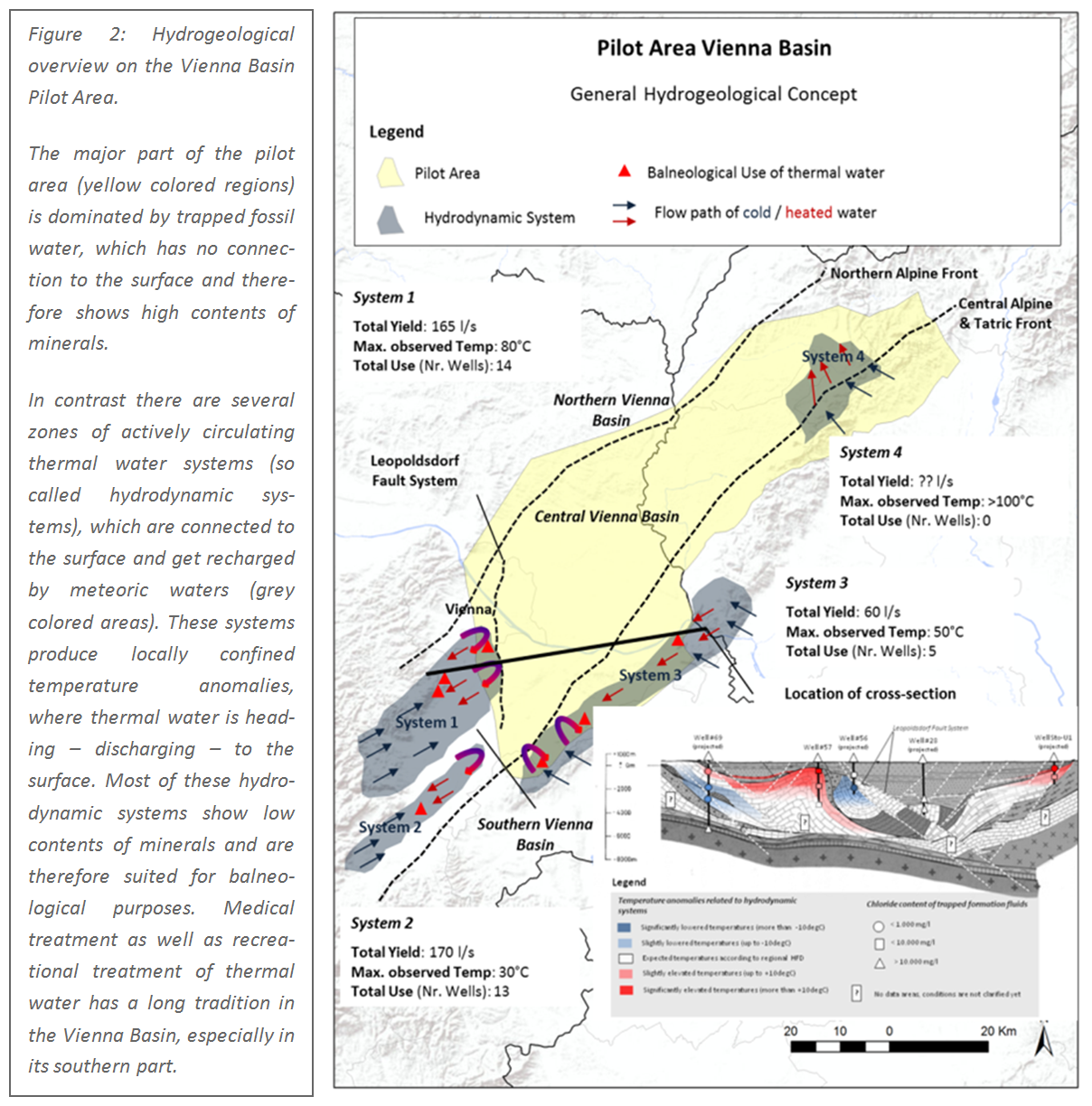
The Vienna Basin indeed offers great possibilities to use geothermal energy in terms of natural occurring thermal water, which can be pumped from the subsurface, cooled down and afterwards re-injected to the subsurface again in order to preserve the so called “reservoir” in a good condition. The use of natural thermal water is called “Hydrogeothermal Use” and is currently still representing the best approved technical way of using the heat stored in the subsurface of the earth. But natural thermal water does not occur everywhere in the subsurface. It is favorably bound to areas of sedimentary basins or carbonate rocks, which offers flow paths for trapped water in a sufficient extend of several cubic kilometers of gross volume.
The Vienna Basin fulfills the above mentioned criteria. It offers various thermal water reservoirs, which are located at different regions as well as depth intervals at the Vienna Basin Pilot Area.
Current state of utilization in contrast to future opportunities and challenges
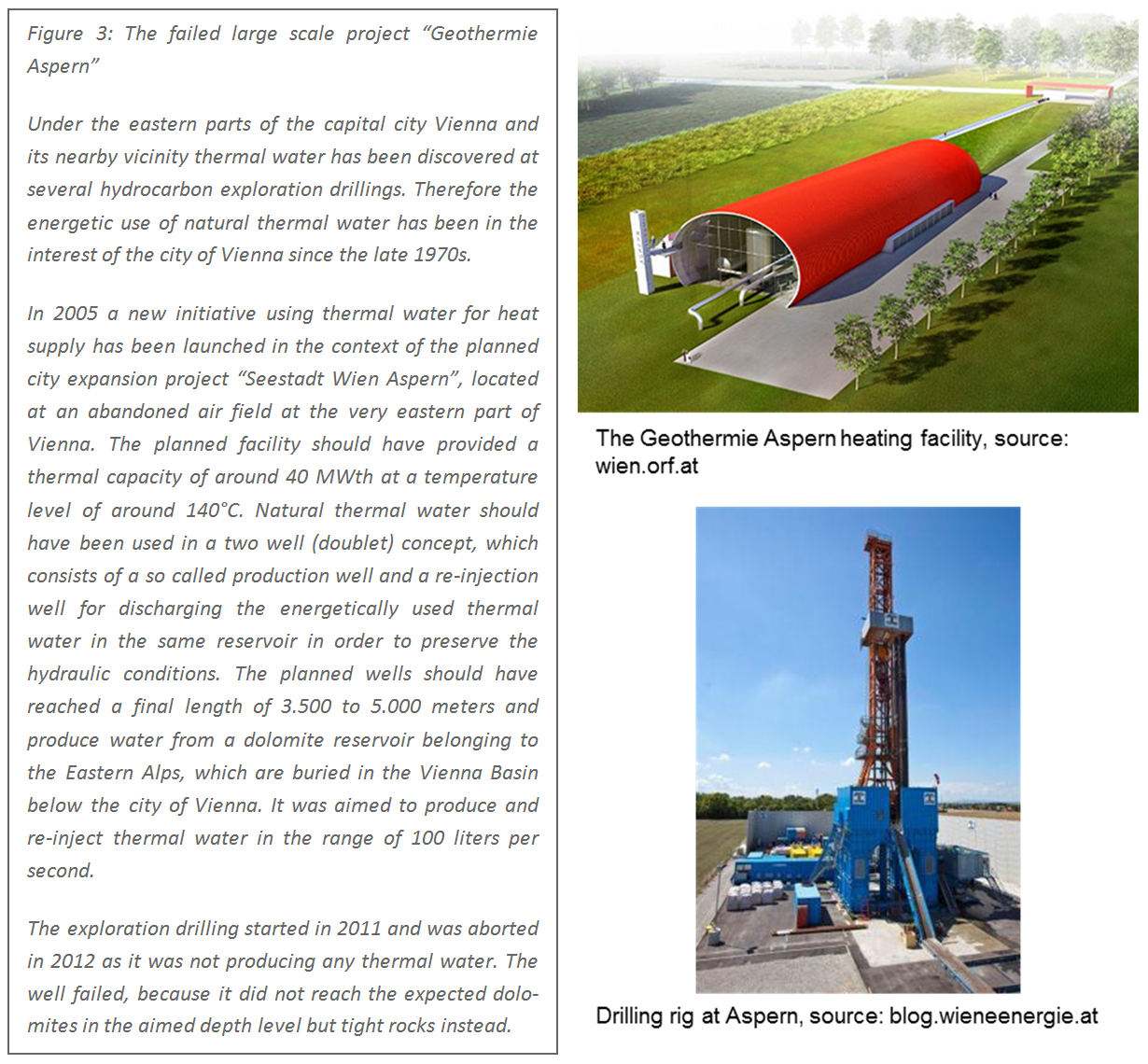
Currently the use of natural thermal water does not play an important role in the Vienna Basin except for balneological use in its southern part. All existing spas are exclusively located in the Austrian part of the Vienna Basin (Baden, Bad Voeslau and Bad Fischau) and have a long tradition. In contrast energetic use of the existing thermal water in the central and northeastern part of the Vienna Basin has not been implemented yet, although there are great resources estimated. The first large scale geothermal heat-supply facility, which should have been in Vienna (project Wien – Aspern) unfortunately failed in 2012 due to a non-successful drilling.
In contrast the subsurface of the Vienna Basin has been extensively used for the production of hydrocarbons since decades. However, as the production of crude oil continuously decreases since the past 40 years it offers future possibilities for hydrogeothermal utilization in the Vienna Basin by:
- Using the knowledge and data gained by the hydrocarbon industry for the assessment of geothermal reservoirs
- Using abandoned or non-profitable oil wells for a hydrogeothermal re-use
- Combined use of hydrocarbon infrastructure for hydrocarbon and heat recovery (e.g. implementation of heat exchangers in pooling stations)
In contrast increasing future geothermal use may also offer challenges and risks of conflicts due to:
- Competitive subsurface use between hydrocarbon production and geothermal heat recovery
- Over-exploitation due to intense use especially at near border regions due to a lacking trans-boundary management of natural thermal water.
In order to avoid future conflicts and assist a reasonable and sustainable future use of natural thermal water in the Vienna Basin several activities have been accomplished during the project Transenergy, which led to various products published on this website.
How can Transenergy help to establish a sustainable future management of thermal water utilization in the Vienna Basin?
The project „TRANSENERGY – Transboundary Geothermal Energy Resources of Slovenia, Austria, Hungary and Slovakia” aims to provide implementation tools based on a firm geoscientific basis for enhanced and sustainable use of geothermal resources in the Vienna Basin.
In order to reach this goal the following main activities have been executed:
- Collection and harmonization of geoscientific data and buildup of a supra-regional web-map service
- Elaboration of geoscientific 3D models covering the entire Vienna Basin pilot area: Based on available geological data geological 3D models has been built up using the software packages Gocad™ and FEFLOW™. The resulting models are published in terms of 3D PDFs, which are showing the temperature distribution on main surfaces of geological structures in the Pilot area as well as showing the contour maps of different temperature levels.
- Elaboration of a web-map service covering the most important reservoirs (so called Hydrogeothermal Plays) in the Vienna Basin Pilot Area. For further information see below.
- Assessment of hydrogeothermal potentials and resources for several identified Hydrogeothermal Plays in the Vienna Basin pilot area. Read more.
- Scenario modelling based on a detailed 3D model for the most prospective trans-boundary Hydrogeothermal Play. Read more.
The achieved products, which are presented on this webpage, constitute a so called “Interactive Web Based Information Tool”, which intends to exhibit the general geothermal conditions in the Vienna Basin, outline relevant structures (Hydrogeothermal Plays) and showing assessed resources concerning a future geothermal use. View the “Interactive Web Based Information Tool”.
Transenergy intends to address policy makers, regulative authorities as well as the interested public in order raise the awareness concerning the possible future use of geothermal energy and provide data models for a future thermal water management. It can’t and does not intend to replace detailed feasibility and site selection studies for specific hydrogeothermal utilizations.
Present and Future Hydrogeothermal Resources
The first step towards a future management of geothermal resources is constituted by assessing the probable and known resources as well as the already installed capacities. There are various ways to assess geothermal resources. The Transenergy team decided to follow the terminology of a recently published Geothermal Reporting Code presented by the Canadian Geothermal Association (CanGEA).
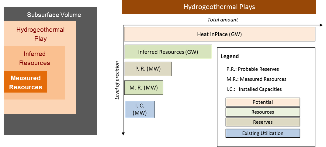
Figure 4: Overview of the different levels of potentials and resources used for the assessment of hydrogeothermal resources in the Vienna Basin pilot area.
The term “Hydrogeothermal Play” covers a distinctive subsurface rock volume (in this case a geological structure) where natural thermal water is supposed to be occurring and may be utilized. The heat stored in such a subsurface volume is called “Heat in Place”. This term delimits the theoretically available geothermal potential, which could only be utilized by cooling down the entire rock volume of the specific Hydrogeothermal Play. In practice it won’t be possible to extract the entire amount of heat stored by technical measures.
If basic data as well as geoscientific models are available in a regional scale, the amount of technically extractable geothermal heat can be estimated at a low level of confidence – defined by the term “Inferred Resources”. We calculated the Inferred Resources by assuming to systematically install geothermal doublets (1 production well + 1 injection well) in order to cover the entire area of a Hydrogeothermal Play at the earth’s surface by placing 1 doublet at an area of 1 km². By doing this the technically recoverable amount of stored heat can be estimated, despite of any economic constraints or considerations.
By considering economic constraints (e.g. maximum drilling depths) the Inferred Resources can be transferred to “Probable Reserves”, which constitute the technically and economically recoverable share of stored heat in a specific Hydrogeothermal Play at a still quite low level of confidence tending to overestimate the “true” reserves.
If more specific information about a reservoir is available as well as the evidence of thermal water in the subsurface is shown in exploration wells the so called “Measured Resources” can be estimated. For the Vienna Basin pilot area the Measured Resources have been estimated based on water inflow observed at hydrocarbon exploration wells. This leads to a more precise estimation of the technically extractable amount of the heat stored in the subsurface.
The highest level of precision is indicated by the term “Installed Capacities”, which delimitates the thermal energy already installed at hydrogeothermal utilizations.
Read more about the assessed hydrogeothermal resources.
Ways Towards a Sustainable Future Management of the Available Hydrogeothermal Resources
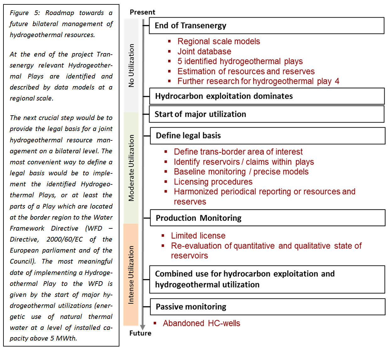
In the moment there is still no extensive hydrogeothermal use in the Vienna Basin pilot area. However, considering the socioeconomic and geoscientific settings in this region a future geothermal utilization has to be expected. In order to avoid over-exploitation at the near- and trans-boundary Hydrogeothermal Plays between Austria and Slovakia a future resource management strategy has been developed in the framework of the project Transenergy. This strategy is founding on the below listed main activities (piles):
- Assessment and bilateral exchange of relevant geoscientific data and build-up of trans-national databases and models
- Monitoring of geothermal utilization and passive monitoring
- Periodical bilateral reporting of resources and production data
- Evaluation of future and existing licenses for geothermal utilization based on numerical modelling.
The above listed actions will not be applied on the entire region, only for relevant Hydrogeothermal Plays identified at the project Transenergy. Furthermore the intensity of applied actions will also depend on the distance to the state border and the level of utilization. The level of utilization is strongly influencing the intensity of needed measures and activities of a joint future hydrogeothermal management. We propose to differ between the following levels:
- No Utilization (current state of the art)
- Moderate utilization: No interference between utilizations and no regional scale changes of quality concerning the Hydrogeothermal Plays
- Intense utilization: Interferences between utilizations and regional scale changes of quality evident.
A detailed description of the proposed measures can be found in the Detailed cross-border monitoring and reporting assessment of pilot areas.
The Vienna Basin pilot area is still at a starting point of a roadmap towards a future bilateral hydrogeothermal management. Now, at the end of the project Transenergy, the available “Web-based Information Tool” is providing data for a future resource management on a predominant regional scale. The next steps of this roadmap are shown in the figure below.
The Web Based Information Tool
The Web based Information Tool on hydrogeothermal resources in the Vienna Basin Pilot Area aims to give an overview about identified relevant hydrogeothermal reservoirs, summarized at so called “Hydrogeothermal Plays” in order to support decisions towards a possible future transnational management of natural thermal water resources. It addresses governmental authorities, decision makers, possible investors as well as experts and the interested public. However, it does not aim to replace detailed surveys or feasibility studies, as most of the published results are presented at a regional geographical level.
The Web Information Tool consists of the following products:
- A detailed Web-Map Service of the Vienna Basin Pilot Area focusing on the identified Hydrogeothermal Plays.
- The results of the achieved resource assessment for the identified Hydrogeothermal Plays
- The results of a detailed scenario modelling study performed for one of the most promising trans-boundary Hydrogeothermal Play (The Juvavic Nappe System Hydrogeothermal Play).
The Web Based Information Tool summarizes the main results of Transenergy and intends to inform, raise awareness and provide sound base data and models.
Web Map Services for the Vienna Basin Pilot Area
The individual Web Map Service for the Vienna Basin Pilot Area shows relevant reservoir data for the following five relevant Hydrogeothermal Plays:
- VB01 – Aderklaa Conglomerate
- VB 02 – Deltafront Sediments
- VB03 – Tirolic Nappe System
- VB04 – Juvavic Nappe System
- VB05 – Central Alpine & Tatric Carbonates
The identified Hydrogeothermal Plays are described at the Section “Resource Assessment” (see below).
For all pilot areas the following uniform list of contents concerning the Web-Map-Service has been chosen:
- Depth of Surfaces (top and basis) of the selected Hydrogeothermal Play using the unit [meters above sea level].
- Gross thickness of the selected Hydrogeothermal Play [meters].
- Temperature distribution at the top and the base of the selected Hydrogeothermal Play [°C].
- Existing Utilizations – not active for the Vienna Basin Pilot Area WMS as there are no major geothermal utilizations to be reported.
- Hydraulic potential – not active for the Vienna Basin Pilot Area WMS as all identified Hydrogeothermal Plays show stagnant hydrostatic to slightly overpressured conditions.
- Pressure changes – not active for the Vienna Basin Pilot Area WMS as there are no data available showing relevant pressure changes due to hydrocarbon production.
All presented layers are derived from regional geological and numerical models achieved during Transenergy. They intend to give an overview about the regional scale geothermal conditions at the identified Hydrogeothermal Plays.
Manual
The pilot area Web-Map-Service is very similar to the Transenergy Web-Map-Service for the supra-regional project area. In order to view the manual click here.
Disclaimer
Data available within the web map application is provided only for a regional overview of geological and geothermal conditions of the TRANSENERGY pilot area Vienna Basin and should not be used for more local potential/reservoir assessment. No permission is granted for use of the data outside this application without written permission of the owner of the data. For further information please contact our project partners.
Hydrogeothermal Resource Assessment at the Vienna Basin Pilot Area
The most important aspects in brief
As there are still no major hydrogeothermal utilizations in the Vienna Basin pilot area, activities have focused on a harmonized assessment of possible resources. Following the Canadian Geothermal Code for Public Reporting published by the Canadian Geothermal Energy Association (CanGEA) the following steps have been performed:
- Identification and description of relevant Hydrogeothermal Plays
- Selection of technical schemes of hydrogeothermal utilization for resource assessment
- Calculation of the stored Heat in Place
- Calculation of Inferred Resources
- Calculation of Measured Resources
- Evaluation of limitations and estimation of Probable Reserves.
All calculations have been performed using 2D Grids, which have been derived from the previous achieved geological and numerical 3D models for the Vienna Basin Pilot Area.
The assessment of the above mentioned different levels of hydrogeothermal resources have been performed for 5 different Hydrogeothermal Plays (subsurface structures with high chances of thermal water) assuming 3 different technical utilization schemes (balneological use, heat supply and electric power generation combined with heat supply).
The assessed hydrogeothermal potential, the so called Heat in Place, varies between 78 GW and 1,646 GW assuming an operational lifetime of 50 years. This has to be understood as the maximum, theoretically available amount of heat stored in the subsurface, which cannot be extracted in practice.
The next level of resource assessment is represented by the so called Inferred Resources, which can be seen as an estimation of the technical extractable amount of heat at a low level of resolution and confidence. Assuming a systematic extraction of the heat stored by various doublets (multiplet scheme) the assessed Inferred Resources vary between 1.6 GW and 161 GW, which in turn corresponds to an heat recovery factor (amount of technical extractable Heat in Place) at a max of 10%.
Considering economic constraints the Inferred Resources correspond to the so called Probable Reserves. By allowing a maximum distance between hydrogeothermal doublets and settlement areas of 1,000 meters, we have calculated the Probable Reserves for the heat supply scheme, which is at a level of 49 GW.
The Measured Resources show a high level of confidence provided by direct measurement at wells. We have calculated the Measured Resources based on water inflow on Austrian hydrocarbon exploration wells. The assessed Measured Resources, which can be seen as the already proven resources, vary between 0.06 GW and 1.6 GW.
In order to summarize the existing hydrogeothermal resources of 5 identified Hydrogeothermal Plays in the Vienna Basin for heat supply have been estimated in the range of at least (already proven) 1.6 GWThand at a max of 161 GWTh(in case of a systematic exploitation of heat based on doublets).
Overview on the identified Hydrogeothermal Plays
Following the terminology of the Canadian Geothermal Code for Public Reporting a Hydrogeothermal Play is defined as a subsurface volume, at which heat can be technically extracted by the means of trapped natural thermal water. For the Vienna Basin Pilot Area Hydrogeothermal Plays have been delineated by major geological structures in terms of geological strata as well as tectonic nappes, which are supposed to bear at least one or more thermal water reservoirs. The spatial as well as geological resolution is limited by the regional scale of the established geological 3D model for the pilot area. That means it has not been distinguished yet between hydraulic conductive rock units or regions within a selected Hydrogeothermal Play (aquifers) and less or none conductive zones (aquitards).
Apart from hydrogeological considerations the selection of relevant Hydrogeothermal Plays was influenced by the expected temperature level (average temperature above 50°C) as well as by aspects concerning the intensity of hydrocarbon production in order to avoid utilization conflicts between hydrogeothermal utilization and hydrocarbon - above all crude oil - production.
Table 1: Overview on the identified Hydrogeothermal Plays
ID |
Title |
Type |
Age and Lithology |
VB 01 |
Aderklaa Conglomerate |
Porous sedimentary layer (Neogene Basin filling) |
Middle Miocene (Lower Badenian), conglomerates |
VB 02 |
Deltafront Sediments |
Porous sedimentary layer (Neogene basin filling) |
Lower Miocene (Eggenburgian - Ottnangian), sandstones and sands |
VB 03 |
Tirolic Nappe System |
Fractured carbonates (basement) |
Upper – Middle Triassic (Norian – Ladinian), dolomites |
VB 04 |
Juvavic Nappe System |
Fractured carbonates (basement) |
Middle Triassic (Anisian – Ladinian), dolomites, limestones |
VB 05 |
Central Alpine & Tatric Carbonates |
Fractured carbonates (basement) |
Middle Triassic (Anisian – Ladinian), dolomites |
The vertical and geographical location of the identified Hydrogeothermal Plays is shown in the figures below. The identified Plays cover the major part of the pilot area and are partly overlapping. They are partly outcropping to the surface (especially VB 05) and reach maximum depths of more than 10.000 meters below surface. The uppermost part of the sedimentary basin filling of the Vienna Basin has been excluded due to still ongoing hydrocarbon production, moderate reservoir temperatures and reduced chances of wide spread reservoirs.
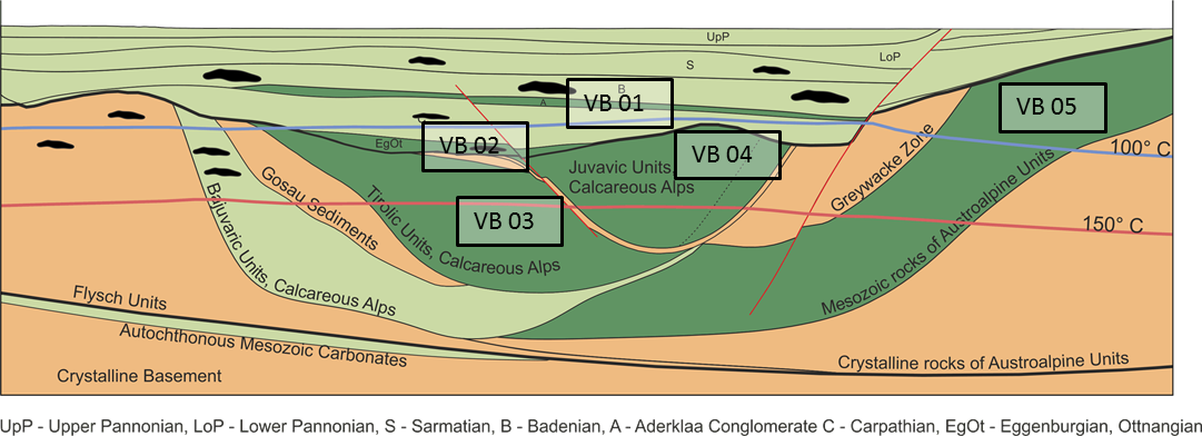
Figure 1: Schematic hydrogeological cross-section through the Vienna Basin Pilot Area showing the location of the identified Hydrogeothermal Plays: Dark green colored areas outline geological units with high chances of thermal water; light green areas represent units with reduced chances of wide spread reservoirs; red colored areas outline tight rocks with low chances on thermal water; black colored zones represent the appearance of hydrocarbon reservoirs.
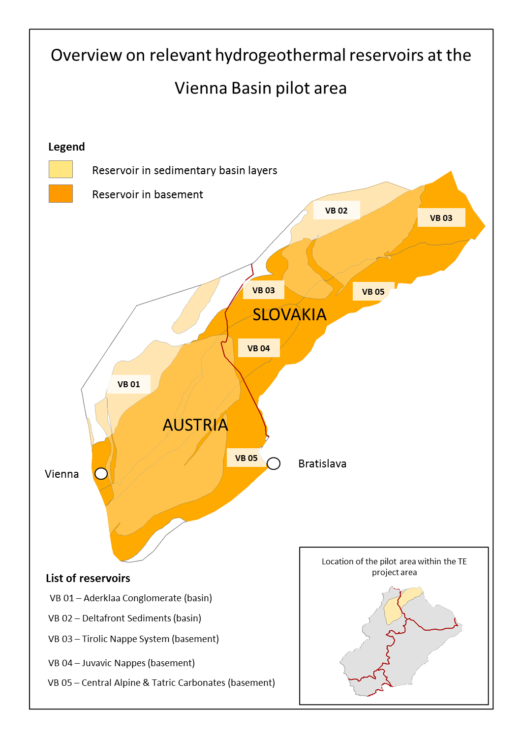 Figure 2: Location of the identified Hydrogeothermal Plays at the Vienna Basin Pilot Area
The geometrical settings of the identified Hydrogeothermal Plays have been derived from an achieved geological 3D model covering the entire pilot area. The calculated rock volumes represent gross parameters also including not resolved zones of non-water bearing rocks within the Hydrogeothermal Plays. In the context of Transenergy the “Gross Aquifer Volume” represents the estimated volume of fluid filled, hydraulically connected pore space including fractures, which were derived by combining the “Gross Volume” and the average hydraulically effective porosity.
The Hydrogeothermal Plays located at the basement rocks of the Vienna Basin (VB 03 – VB 05) show great maximum depths of up to more than 10,000 meters below surface, which are currently not applicable from a technical and economic point of view.
Table 2: Geometrical parameters of the identified Hydrogeothermal Plays
ID |
Title |
Average Thickness |
Maximum Depth |
Gross Volume |
Gross Aquifer Volume |
|
|
m |
m.b.s |
km³ |
km³ |
VB 01 |
Aderklaa Conglomerate |
747 |
4,470 |
248.728 |
37.309 |
VB 02 |
Deltafront Sediments |
666 |
4,880 |
123.657 |
21.269 |
VB 03 |
Tirolic Nappe System |
6,624 |
9,080 |
4,495.399 |
265.229 |
VB 04 |
Juvavic Nappe System |
4,634 |
7,410 |
900.403 |
30.614 |
VB 05 |
Central Alpine & Tatric Carbonates |
6,359 |
10,750 |
3,219.976 |
103.039 |
m.b.s. meters below surface
In order to calculated the hydrogeothermal resources thermal- as well as hydraulic rock parameters had to be estimated for the identified Hydrogeothermal Plays. The below listed data have been derived from measurements achieved by the involved Geological Surveys as well as from archive data stored at the surveys. As the assessment of resources is performed at a regional scale and only a few data were available for some Hydrogeothermal Play, we have chosen to only use uniform values for each Hydrogeothermal Play, which were represented by average values. Local variations of the rock properties within the Hydrogeothermal Plays could not be considered.
The Volumetric Heat Capacity is governing the heat transfer between the hydrogeothermal reservoir (Play) and the geothermal doublet (production- and injection well). The hydraulic conductivity and respectively the transmissivity (combination of hydraulic conductivity and the thickness of a reservoir) are in turn governing the flow rate of thermal water and pressure change, respectively, between the reservoir and the doublet.
Table 3: Thermal and hydraulic parameters used for the assessment of hydrogeothermal resources
ID |
Title |
Volumetric Heat Capacity1 |
Hydraulic Conductivity |
Transmissivity |
|
|
MJ / ( m³ x K) |
10-6 m/s |
10-3 m²/s |
VB 01 |
Aderklaa Conglomerate |
3.137 |
1.63 |
0.32 |
VB 02 |
Deltafront Sediments |
2.735 |
1.96 |
0.36 |
VB 03 |
Tirolic Nappe System |
3.019 |
0.52 |
1.16 |
VB 04 |
Juvavic Nappe System |
2.812 |
0.52 |
1.01 |
VB 05 |
Central Alpine & Tatric Carbonates |
2.565 |
0.52 |
1.01 |
1 Bulk value of the fluid filled rock volume
Description of the selected hydrogeothermal utilizations schemes
The assessment of hydrogeothermal resources is strongly depending on the assumed utilization scenario. The governing parameters are given by: (1) The minimum required temperature of the thermal water, (2) the thermal efficiency of the utilization (discharge or reinjection temperature) and (3) the type of utilization (single well use or doublet well use). From an ecologic and economic point of view a doublet-well utilization consisting of a production well (water extraction) and a reinjection well is more favorable than a single-well use, as the pressure at the reservoir can be preserved by injection of cooled down water as well as the fact, that critical waters may not be discharged to rivers or creeks. It has to be pointed out, that balneologically used thermal water is not allowed to be re-injected to the reservoir for hygienic reasons.
We have selected 3 different schemes, which are representing the most common utilization schemes:
Table 4: Overview of the utilization schemes selected for hydrogeothermal resource assessment
ID |
Title |
Required minimum temperature |
Reference temperature (discharge, re-injection) |
Type of scheme |
Constraints |
|
|
°C |
°C |
- |
- |
1 |
Balneology (energetic use of water for local heating) |
30 |
10* |
Single Well |
None |
2 |
Heat Supply (district heating as well as individual heating) |
40 |
25 |
Doublet (2 wells) |
Maximum flow rate 100 l/s or max. drawdown of 100 meters** |
3 |
Electric Power Generation (combined with heat supply) |
105 |
55 |
Doublet (2 wells) |
Maximum flow rate 200 l/s or max. drawdown of 200 meters** |
* Equals the surface temperature as the extracted thermal water will not be re-injected to the subsurface, therefore a high efficiency is presumed for the energetic use of the trapped thermal water (e.g. heating of spa facilities).
** Maximum drawdown of the water table at the production well, estimated by correlation to the transmissivity of the Hydrogeothermal Play at a specific location
For all chosen schemes an operational period of 50 years at an annual full load was assumed.
Assessment of Heat in Place
The term “Heat in Place” describes the amount of heat stored within a specific rock volume. It represents a theoretical quantity describing the thermal potential reflecting the surface volume, the temperature conditions as well as the thermal rock parameters. In practice it is not possible from a technical point of view to extract the entire amount of heat stored in a subsurface volume. However, the term Heat in Place confines the (theoretically) available maximum amount of heat. The Heat in Place was calculated for every Hydrogeothermal Play with respect to the above described utilization schemes.
The table below shows the estimated reservoir temperatures at the identified Hydrogeothermal Plays, derived from a steady state pure conductive 3D model covering the entire pilot area. The estimated great reservoir temperatures at the deep buried sections of the Hydrogeothermal are of course not proven, as these sections have not been drilled yet.
Table 5: Calculated reservoir temperatures of the selected Hydrogeothermal Plays, derived from numerical 3D modelling (steady state conductive model)
ID |
Title |
Average temperature |
Maximum temperature |
Observed maximum temperature1 |
|
|
°C |
°C |
°C |
VB 01 |
Aderklaa Conglomerate |
80 |
114 |
100 |
VB 02 |
Deltafront Sediments |
58 |
155 |
85 |
VB 03 |
Tirolic Nappe System |
118 |
239 |
165 |
VB 04 |
Juvavic Nappe System |
129 |
193 |
128 |
VB 05 |
Central Alpine & Tatric Units |
134 |
282 |
73 |
1 Data only for Austrian wells available
The calculated Heat in Place is shown in the table below.
Table 6: Calculated Heat in Place associated to the identified Hydrogeothermal Plays
ID |
Title |
Heat in Place (MWTh, 50 years) |
||
|
|
Balneological scheme |
Heat Supply scheme |
Electric power generation scheme |
VB 01 |
Aderklaa Conglomerate |
5,449 |
28,794 |
454 |
VB 02 |
Deltafront Sediments |
1,153 |
7,422 |
1,289 |
VB 03 |
Tirolic Nappe System |
52,998 |
858,027 |
587,344 |
VB 04 |
Juvavic Nappe System |
6,533 |
194,102 |
122,013 |
VB 05 |
Central Alpine & Tatric Units |
12,628 |
557,686 |
380,336 |
TOTAL SUM |
78,760 |
1,646,031 |
1,091,436 |
|
Please note that the above shown hypothetical thermal capacities cannot be entirely used by any technical means! The above shown potential may be interpreted as a physical limitation: For example, it is not possible to extract thermal power in the range of more than 450 MWTh (approx. 5 MW electric power) at the Aderklaa Conglomerate by any technical measures.
Assessment of Inferred Resources
The term “Inferred Resources” estimates the technical extractable amount of heat at a quite low level of resolution and confidence tending to overestimate the “real resources”. However, this term gives a by far better estimate of existing technical limits than the so called Heat in Place. It is also suitable to use the Inferred Resources in order to compare the relevance of different Hydrogeothermal Plays at different technical utilization schemes. At Transenergy we have chosen the following approach in order to calculate the Inferred Resources:
Based on the modelled geometry and temperature conditions as well as based on the derived thermal as well as hydraulic reservoir parameters for the identified Hydrogeothermal Plays we have assumed to put one individual hydrogeothermal doublet (1 production well + 1 injection well) at one square kilometer at the surface area confined by an individual Hydrogeothermal Play. Doing so, the entire area will be systematically developed by numerous doublets, which lead to so called “multiplet (multi-doublet) scheme”. For the assumed technical scheme 1 (balneological use) a similar approach has been used assuming one single well at an area of one square kilometer. By correlating the maximum allowed drawdown at the production well of an individual doublet to the estimated transmissivity at a specific location, the maximum yield (extraction rate = injection rate of the used thermal water) can be calculated. In order to avoid unrealistic yield the maximum yield of an individual doublet was limited to 100 l/s. Finally, the thermal power of an individual doublet at a specific cell of 1 km² was calculated for the estimated average temperature and the maximum allowed yield at the specific location. Of course the above mentioned minimum criteria associated to the different utilization schemes will be considered for each location. The total amount of inferred resources will be calculated by summing up the thermal power of the individual doublets for all cells, which fulfill the minimum temperature requirement.
Table 7: Inferred Resources calculated for the identified Hydrogeothermal Plays at the Vienna Basin pilot area.
ID |
Title |
Inferred Resources (MWTh) |
||
|
|
Balneological scheme |
Heat Supply scheme |
Electric power generation scheme |
VB 01 |
Aderklaa Conglomerate |
636 |
14,285 |
229 |
VB 02 |
Deltafront Sediments |
199 |
4,455 |
835 |
VB 03 |
Tirolic Nappe System |
459 |
66,624 |
46,242 |
VB 04 |
Juvavic Nappe System |
72 |
15,567 |
10,945 |
VB 05 |
Central Alpine & Tatric Units |
264 |
60,547 |
41,756 |
TOTAL SUM |
1,630 |
161,478 |
100,007 |
|
Except for the balneological scheme, the calculated Inferred Resources are representing only approximately 10% of the calculated Heat in Place. Of course those Hydrogeothermal Play, which are affected by great depths and reservoir temperatures, respectively, show by far higher Inferred Resources than the Hydrogeothermal Plays located at the Neogene Basin fillings (limited thickness and depth). It has to be kept in mind, that the Inferred Resources do not consider any economic constraints, such like maximum drilling depths.
Assessment of Measured Resources
Measured Resources are representing a high level of confidence by applying data from direct measurements in deep drillings. We have calculated the Measured Resources based temperature data measured in hydrocarbon exploration wells. Doing so only those cells have been considered, where exploration wells have been drilled using the above described workflow for the different utilization schemes. All considered hydrocarbon wells have shown significant inflow of thermal water. In addition the temperature measurements have been directly applied on the inflowing water. Therefore the calculated Measured Resources can be seen as proven resources.
Table 8: Inferred Resources calculated for the identified Hydrogeothermal Plays at the Vienna Basin pilot area.
ID |
Title |
Measured Resources (MWTh) |
||
|
|
Balneological scheme |
Heat supply scheme |
Electric power generation scheme |
VB 01 |
Aderklaa Conglomerate |
6 |
114 |
0 |
VB 02 |
Deltafront Sediments |
1 |
28 |
0 |
VB 03 |
Tirolic Nappe System |
36 |
1,007 |
349 |
VB 04 |
Juvavic Nappe System |
10 |
461 |
102 |
VB 05 |
Central Alpine & Tatric Units |
5 |
20 |
0 |
TOTAL SUM |
60 |
1,630 |
450 |
|
The Measured Resources are representing only a very small share of the Inferred Resources (less than 1%). Furthermore only Austrian wells could be considered in the estimation as there were no data available from Slovakia. In addition it has to be considered, that hydrocarbon wells have been drilled for the exploration of oil and gas, not for thermal water. Therefore Measured Resources are in general underestimating the true resources. However, it can be summarized that around 1.6 GWTh are already proven considering the Heat supply scheme and 450 MWTh (corresponding to around 30 - 40 MWEl) are proven for the Electric power generation scheme.
Estimation of Probable Reserves
The term Reserves describes both the technical as well as economical extractable amount of heat stored in the subsurface. Probable Reserves correspond to Inferred Resources by outlining the share, which can be developed in an economically feasible way. There are various economic constraints controlling the feasibility of hydrogeothermal utilizations. Most of them are very site specific and are difficult to generalize (e.g. the load profile of local users). However general constraints are given by the maximum drilling depth and the distance to existing settlement zones. In order to give a rough estimation about Probable Reserves we have considered the limitations given by the distance to existing settlement areas. By assuming a maximum distance of 1,000 meters to settlements the Probable Reserves have been assessed for the heat supply utilization scheme.
Table 9: Probable Reserves calculated for the identified Hydrogeothermal Plays considering the heat supply utilization scheme.
ID |
Title |
Probable Reserves (MWTh) |
|
|
Heat supply scheme |
VB 01 |
Aderklaa Conglomerate |
816 |
VB 02 |
Deltafront Sediments |
87 |
VB 03 |
Tirolic Nappe System |
22,688 |
VB 04 |
Juvavic Nappe System |
5,292 |
VB 05 |
Central Alpine & Tatric Units |
20,391 |
TOTAL SUM |
49,273 |
|
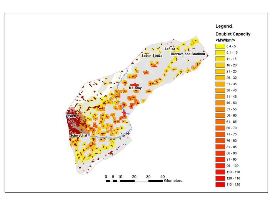
Figure 3: Probable Reserves: Hydrogeothermal doublet capacity per km² combined for all investigated Hydrogeothermal Plays. Settlement Areas: Eurosat©, Corrine Landcover (2006)
Considering a maximum distance of 1.000 meters the estimated Probable Reserves associated to the heat supply scheme are in the range of 49 GWTh. The resulting hot spots for hydrogeothermal heat supply are located at the surrounding of the capital city Vienna and at the Austrian – Slovakian border region between Malacky and Schoenkirchen / Aderklaa.
The detailed scenario modelling study
Introduction
For each pilot area detailed scenario modelling studies have been performed during Transenergy. As there are no major hydrogeothermal utilizations yet existing in the Vienna Basin pilot area, the performed scenario modelling was focused on the estimation of resources for a hydrogeothermal doublet use in one of the most promising near-boundary structures of the pilot area – the so called “Wetterstein Dolomite” structure within the Hydrogeothermal Play VB 04 – Juvavic Nappe System.
The Wetterstein-Dolomite geothermal reservoir has been figured out to be the most promising trans-boundary geothermal reservoir in the Vienna Basin pilot area. Because of the high salinity of the thermal waters of this aquifer the trapped thermal water is not suited for balneological purposes. Hence, the only possible utilisation can be a pure energy usage, realized by a doublet installation with complete reinjection of the thermally deployed brine. As this Hydrogeothermal Play has not been used for geothermal use yet, the scenario modelling is focusing und possible future near-boundary utilization schemes.
The main objectives of the detailed scenario modelling are represented by:
- Analyses of the hydraulic influence of (i) fault systems and (ii) the geometrical shape of the reservoir on the coupled hydraulic and thermal conditions of different doublet-use scenarios, represented by different locations and operational settings.
- Estimation of the technically extractable amount of heat by assuming several hydrogeothermal doublets.
The area of interest shows a lateral extension of about 15 km x 3 km, striking approximately along a SE-NW direction. The river March and the Austro-Slovakian boarder crosses the body right in the middle in N-S direction. On the Austrian side, large parts of the watersides of the river March are protected by “Natura 2000 - European Nature Reserve”. Hence no surface hydrogeothermal installations, such as wells or heating facilities are considered to be legally allowed in this area. In opposite “Záhorie Protected Landscape area” is situated on the Slovakian side along the river Morava / March. Despite of this fact, the location of the Slovakian hydrogeothermal doublets has been set within this protection area nearby the village of Visoká pri Morave. This was done in order to investigate possible trans-boundary hydraulic flow and thermal influences at the reservoir.
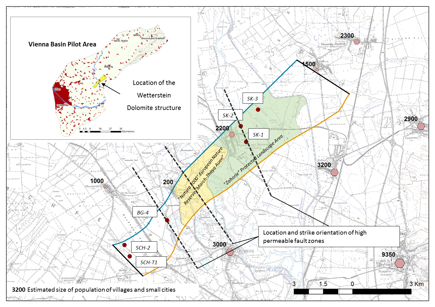
Figure 1: Location of the Wetterstein Dolomite structure, combined with the location of assumed hydrogeothermal doublets and hydraulically conductive fault zones investigated at the scenario modelling study.
On the Austrian side of the reservoir three abandoned hydrocarbon wells (SCH-T1, SCH-1 and BG-4) could possibly be used (re-entry) for geothermal usage and supply the Gänserndorf / Strasshof area (approx. 20.000 inhabitants) with energy (heat and electric power). At least the above mentioned drillings have proofed the evidence of thermal water at the investigated reservoir. On the Slovakian side we considered the Zohor – Láb – Záhorská Ves triangle containing about 10.000 inhabitants as a plausible area for geothermal supply of heat.
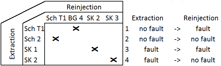
Description of scenarios
At each modelling run two doublets - one on the Austrian and one on the Slovakian side of the reservoir - are simulated at a time, so basically two runs are sufficient to simulate the combinations. Doublette [1] and [3] (see also the figure below) were considered in 'scenario 1' and the doublettes [2] and [4] in 'scenario 2'. Additionally, the influence of a 50 metres thick layer of Breccia at the base of the neogene Sediments was surveyed in 'scenario 3'.
As no hydrogeothermal utilization has been developed yet for this hydrogeothermal structure, the applied scenario modelling is focussing on the coupled hydraulic – thermal influence of the anisotropic shape of the reservoir (low ratio of lateral- to the longitudinal extension of the reservoir) and assumed high permeable discrete fault zones, which may act as flow channels for the injected cold water. In addition hydrocarbon drillings in the vicinity and partly within the Hydrogeothermal Play itself show the evidence of a high hydraulically conductive porous aquifer at the lowermost 50 meters of the Neogene deposits, which are directly overlaying the target reservoir. This assumed porous sedimentary layer would lead to an coupled hydraulic – thermal interflow between the wells of the doublet, which may be different to the fault related interflow. As the fault related interflow acts as a discrete flow channel, the porous layer interflow may act as a volume related interflow, which may lead to a later but smoother thermal breakthrough at the production well of a doublet. In contrast a channel related interflow is, in the worst case (both wells are located at the same conductive fault zone), expected to lead to a short thermal breakthrough time and an massif decrease of the temperature at the production well.
Table 1: Overview on the investigated scenarios
Scenario |
Involved Doublets |
Description |
1 |
Austria: Sch2 (P) – BG4 (I) Slovakia: SK1 (P) – SK2 (I) |
High influence of fault zones: At the Austrian doublet the injection well is located at a fault zone, which may lead to a fast propagation of the cold water plume. In contrast it also may reduce the technical effort of the water injection. At the Slovakian side both wells are influenced by a high permeable fault zone, which may strongly enhance both hydraulic and thermal short-cuts. |
2 |
Austria: Sch2 (P) – Sch (I) Slovakia: SK2 (P) – SK3 (I) |
Moderate influence of fault zones: Both wells of the Austrian doublet are located at tectonically undisturbed positions of the reservoir, which may on one hand lead to enhanced hydraulic resistivity at the wells but on the other hand inhibits thermal short-cuts. At the Slovakian doublet the production well is located within a high permeable fault zone. As the injection well is located at an assumed tectonically undisturbed position of the reservoir, the thermal breakthrough may be inhibited on the one hand, but the effort in order to inject the used water may be raised on the other hand. |
3 |
Austria: SchT1 (P) – Sch 2(I) Slovakia: SK2 (P) – SK3 (I) |
Influence of a high permeable porous layer on the top of the Weeterstein Dolomite reservoir: Existence of a highly conductive layer at the lowermost 50 meters of the Neogene sedimentary deposits upon the reservoir, which may lead to thermal shortcuts. Additionally, the well screens on the Austrian side are set directly underneath the brecciated high permeability layer to demonstrate a quick thermal breakthrough. |
P... Production well, I... Injection well
It is also making a difference which of the two wells of a doublet is located at the fault zone. There are 3 different schemes, which can be distinguished:
- Both wells are located within the fault zone: Strong directive, channel like interflow between the two wells of the doublet leding to a fast and massive attenuation of the temperature at the production well. From a hydraulic point of view the efforts for production and injection of thermal water (pumping effort) is reduced due to lowered hydraulic transfer resistance between the screen of the wells and the reservoir. This situation was assumed at the Slowakian doublet at scenario 1.
- The injection well is located within the fault zone: From a technical point of view the reinjection of (thermal) water is more sensitive to hydraulic and technical failures and more likely to be non-successful than the production of water (e.g. scaling due to temperature changes of the used thermal water). Therefore the hydraulic transfer resistance between the screen of the well and the reservoir should be as low as possible. This in turn is a strong argument for placing an injection well within a high permeable fault zone. From a thermodynamic point of view a channeled water interflow at the reservoir may lead to two different effects: (1) Shortened thermal breakthrough periods due to reduced heat-transfer surfaces between the flow channels (bearing cold injected water) and the surrounding hot rock matrix. (2) In contrast cold water has a higher density than hot water and therefore is tending to sink towards the deeper parts of the hydraulically connected reservoir due to gravitational forces. As a consequence of this, hot water is displaced to shallower parts of the reservoir, which may lead to a rise of the water temperature in the production well. This scheme is represented at the Austrian doublet in scenario 1.
- The production well is located within the fault zone: As described above the technical and consequently economic gain of placing the production well in a fault zone is less than placing the injection well in the fault zone. On the other hand, the risk of enhanced or interflow leading to uncontrolled or hardly predictable changes of the temperature at the production well is lower than at scheme 2. This scheme is represented at the Slovakian
Taking into account all possible effects and transport phenomena described at the three different schemes, it can be summarized, that scheme (ii) is assumed to be the preferred doublet scheme of a geothermal doublet located in a fault zone affected reservoir.
Results
The susbequent figure shows the results of the coupled thermal – hydraulic scenario modelling in terms of the predicted water temperature at the production wells of the Austrian as well as the Slowakian doublet for an overall time period of 100 years.
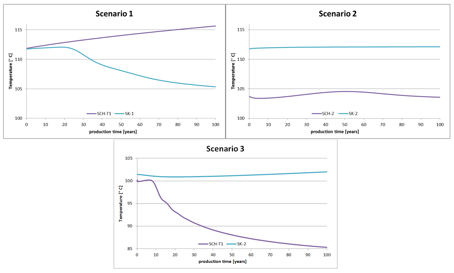
Figure 2: Time series showing the predicted temperature at the production wells of the Austrian and Slowakian doublets.
Scenario 1, which has been labeled as highly influenced by a high permeable fault zone, is showing significant changes due to convective heat transport within the assumed high permeable fault zones. The temperature at the production well of the Austrian well is continuously rising during the production period of 100 years. As described at scheme (ii) in the previous chapter this temperature rise is related to hot thermal water from the deeper parts of the reservoir, which has been replaced by sinking injected cold water. In contrast the thermal evolution of the production well at the Slovakian doublet is smoothly falling after an operational period of approximately 25 years due to enhanced interflow during the fault zones, where both wells are located. This scenario is presenting scheme (ii) described in the previous chapter.
Scenario 2 is represented by minor influences on both the Austrian and Slovakian doublets. While at the Austrian doublet both wells are located at tectonically undisturbed parts of the carbonate reservoir (lack of high conductive fault zones), only the production well of the Slovakian doublet is located within the fault zone. The interflow between the wells of the Austrian doublet is dominated by anisotropic volume flow through a moderate conductive reservoir. Therefore no thermal breakthrough has been observed for an operational period of 100 years at a well distance of approximately 1 kilometer. The temperature history at the Slovakian production well shows a slight temporally confined temperature-rise, which is assumed to be related to upstream of thermal water from deeper parts of the reservoir due to pressure decrease as a consequence of water production. It can be summarized, that both doublets simulated at scenario 2 (low influence of fault zone) are leading to stable temperature conditions at the production well.
Scenario 3 is investigating the influence of a highly conductive porous sedimentary layer on the top of the fractured basement. Such basal breccia and conglomerates, which are hydraulically connected to the fractured basement below, are widely spread over the Vienna Basin. In order to investigate a so called worst case scenario the wells of the Austrian doublet have been set in tectonically undisturbed locations within the Wetterstein Dolomite structure. Therefore the resulting flow paths are forced to pass the overlaying conductive porous layer. In contrast to the situation at the Austrian doublet the production well of the Slovakian well has been set on a highly conductive fault zone. The modelling results show a strong interference between the injection and the production well of the Austrian doublet. After a time period of approximately 10 years there is a massive temperature decline observed at the production well of almost 15°C as the cold water plume is preferentially passing the highly porous sedimentary layer at the top of the reservoir. In that case the Austrian doublet would fail. In contrast the production well of the Slovakian doublet does not show any interference, although the injected cold water plume also passes the highly conductive sedimentary layer above the reservoir. This is due to the fact, that the water pathways associated to the production well are preferably located within the highly conductive fault zone. This in turn reduces the pressure gradient within the overlaying, highly conductive porous layer and inhibits the propagation of the cold plume.
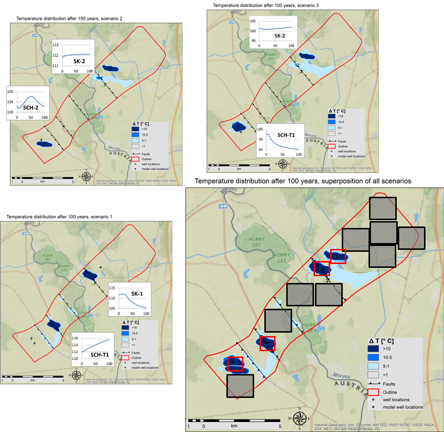
Figure 3: Horizontal cross section through the cold water plumes at the end of the operational period of 100 years for the scenario 1 to 3. Red squares represent the area of one square kilometer assumed as the area needed for the multiplet scheme. Black colored rectangles represent the area needed for a hydrogeothermal doublet based on the results of the scenario modelling studies.
Videos of the scenario modelling
See the results of the 3 different scenarios modelling in our video stream. Please find the links to the videos as well as their description in the selection table below.
Scenario |
Title |
Video |
Annotations |
Scenario-1 |
High influence of fault zone |
||
Scenario-2 |
Moderate influence of fault zone |
||
Scenario-3 |
Influence of high permeable porous layer |
Conclusions
The results of the different scenario modelling studies can be used for the assignment of hydrogeothermal claims (zone assigned to single hydrogeothermal doublet utilizations). As shown in figure 3 in terms of black and grey colored rectangles in total 9 hydrogeothermal doublets could be installed in the outlined Wetterstein Dolomite structure irrespective of natural reserve zones. The average installed power of the modelled doublets is around 25 MWTh, therefore the total sum of all installed doublets would be in the range of around 230 MWTh. This result is now compared with the outcomes of the regionals scale resource assessment in term of the so called Inferred Resources (per square kilometer) considering the electric power generation multiplet scheme.
The comparison is shown in figure 3 in terms of red colored squares of one km² as well as in the below shown figure 4:
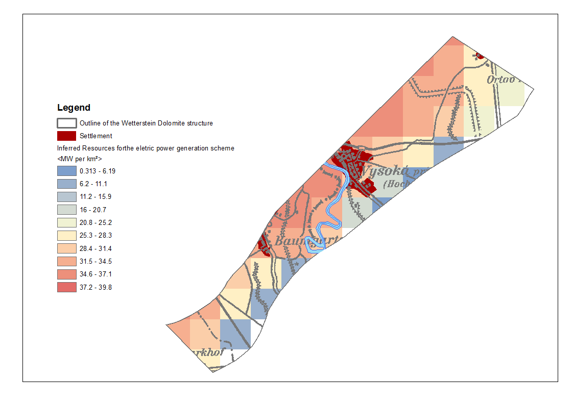
Figure 4: Calculated Inferred Resources based on the multiplet scheme considering the technical utilization scheme “electric power production”, which have been cut out at the outlines of the Wetterstein Dolomite structure.
The estimated hydrogeothermal capacities per square kilometer are varying between 9.6 MWTh and 35.9 MWTh. The average installed capacity of 29.3 MWTh is fitting quite well to the average thermal power derived by the scenario modelling studies. By summing up all cells, which are entirely covered by the Wetterstein Dolomite structure the total Inferred Resources are in the range of 470 MWTh, which is about 2 times larger than the total available resources derived from the detailed modelling studies. The reason for this is given by a too optimistic assumption considering the needed space of a single hydrogeothermal doublet in the raster based estimation of Inferred Resources. As shown by the red colored squares at figure 3, the modelled cold water plume exceeded the assumed one square kilometer area for a single hydrogeothermal doublet.