Introduction
Lutzmannsburg-Zsira pilot area is situated at the central part of the TRANSENERGY project area, located in the transboundary zone of Austria and Hungary. High elevated mountains surround the Oberpullendorf Basin representing the western part of the pilot area, which is gradually lowering eastward into the southern part of the Little Hungarian Plain (Kisalföld). The elevation of the mountains vary between 400-900m and on the lowland area the lowest point is 119m asl.
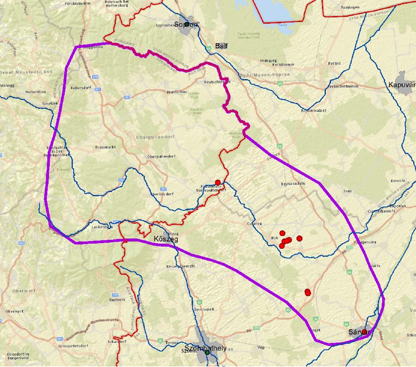
Fig. 1. Thermal wells at Lutzmannsburg_zsira pilot area
This rural area holds mainly villages and small cities with 60.000 inhabitants. Balneology and balneologic tourism are important parts of the regional economy. There are famous spas operating both sides of the national border, such as Sárvár, Bük and Lutzmannsburg. In addition to the well-known spas, there are several smaller users, like hotels or baths in the region, and further demand for new balneological utilizations exist.
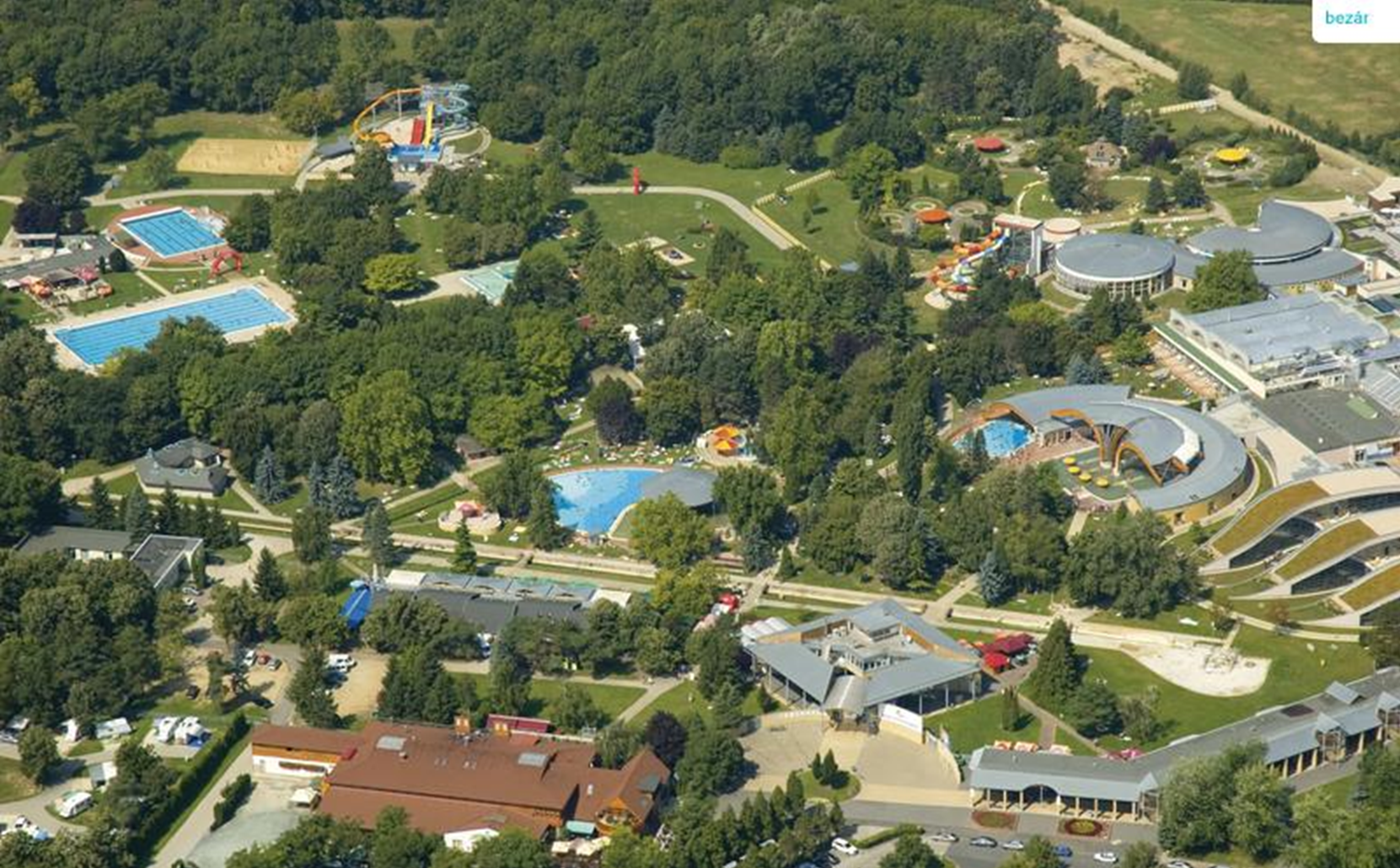
Fig. 2. Thermal spa at Bükfürdő
Due to the favourable geothermal conditions the energetic utilization of geothermal resources is a potential for the area. Locally, especially in the smaller cities the energy demand can meet the untapped resources. One of the aims of the TRANSENERGY project was to outline these prosperous regions within this pilot area.
Geology, hydrogeology and geothermal conditions
The Lutzmannsburg – Zsira area has no natural, geological borders. The basement consists mainly of metamorphosed crystalline rocks of the Austroalpine (Semmering- Wechsel System) and the Penninic (Rechnitz window) units outcropping in the western margin of the area. These units form different nappe systems thrusted on each other. In addition to the metamorphic crystallines, the Devonian Bük Dolomite Formation is an important unit of the basement, as it stores most of the thermal water in the region. The basement is covered with Neogene sediments which deposited in morphological depressions on the tectonically preformed surface of the crystalline basement units. The Upper Miocene-Pannonian porous sediment series has growing thickness toward E-SE. The maximum thickness is 2000m at the eastern part of the region. The sedimentary succession is built up of varying layers of sand, silt and clay. In the older Miocene units sandy limestone or calcareous sand layers occur locally which has special importance from a geothermal point of view.
The main recharge of thermal groundwater is from infiltrating precipitation in the high elevated mountain region, mainly situated in Austria. Part of the infiltrated precipitation returns to the surface after a short path forming local flow systems. The other part is infiltrating toward the deeper layers and enters the regional flow system. At higher depths, along the deeper flowpaths the groundwater warms up, and changes its chemical character due to water-rock interactions. In some places where the basement is connected to the porous sediment formations filling the Neogene basins, the groundwater of the basement aquifers pass water to the porous layers. Otherwise the flow system of the basement is separated from the porous aquifers. The direction of groundwater flow in the Miocene-Pannonian sediments is W-E, than groundwater partly flows towards the Marcal river, or turns to N-NE to the direction of the Hanság region. The main groundwater discharge areas (rivers and river alluvial valleys especially the Marcal river) are out of the model territory. In natural conditions several wetlands, especially Hanság had an important role in groundwater discharge. Recently there are only small patches of wetlands left, furthermore the dense artifical drainage channel network functions as groundwater discharge.
The geothermal conditons can be characterized with available maximum temperature, which is increasing eastward parallel with the basement depth. It starts to decrease at the SE margin of the area, where the basement is rising again toward the outcropping Transdanubian Midmountains. The highest temperature occur in the Szombathely-Sárvár zone, where the temperature of the basement varies between 80-110°C.
The deepest temperature measurements were done in the crystalline basement at Egyházasrádóc (Rád-1) in the depth of 3401.5m, where the temperature reached 115.8°C. The Rád-2 borehole discovered 112°C in 2950m depth.
Geothermal reservoirs
Three different reservoirs have been identified in the pilot area: Upper Pannonian porous reservoir, Miocene porous reservoir locally with double porosity, and basement fractured carbonate reservoir (Bük Dolomite).
The Bük Dolomite aquifer situated in separated blocks, at more than 1000m depth. These blocks have complex hydraulic connection with neighbouring reservoirs, which results in different hydrochemical caharacteristics. The block below the Bük region has restricted recharge, with lower (4000-14000mg/l) total dissolved content concentration. The other block near can be characterized with high total dissolved content. One type of Miocene reservoirs formed from grained sediments, conglomerate, sand, sandstone, deposited at nearshore environment. These layers can be considered as porous thermal water reservoirs, with often direct hydraulic connection to the basement reservoirs. The Lutzmannsburg spa uses this Carpathian aquifer at a depth of 450-900m.
The other type Miocene thermal water aquifers are the widespread Badenian and the Sarmathian shallow-marine clastic carbonates. The thickness of the Badenian units varies between 10-60 meters, while that of the Sarmathian ones between 50-120 meters. They are considered as reservoirs with double porosity. This type of reaservoir is known only from hydrocarbon exploration wells, and is not targeted by geothermal wells.
The Late Miocene sediments deriving from the surrounding Alpine-Carpathian mountain belt via large fluvio-deltaic systems prograde from the northwest and northeast. These sedimentsform a vast porous basin filling complex.hosting important reservoirs of thermal groundwater. Lower Pannonian layers mainly consist of clay, or sandy clay therefore act as regional aquicludes. The Upper Pannonian sedimentary succession is built up of altering sand and sandy clay layers. The entire sedimentary succession form one hydrostratigraphic unit. Within this thick Upper Pannonian sedimentary complex the best reservoirs are those large sand bodies which once deposited on the front of the prograding delta-systems. These delta-front sandstones can be characterized by intergranular permeability and confined groundwater levels. The reservoir has good hydraulic connection both vertical and horizontal direction, which ensure continuous recharge and low total dissolved content (below 2000mg/l) in thermal water. This reservoir is used in Bük, Sárvár and Szeleste.
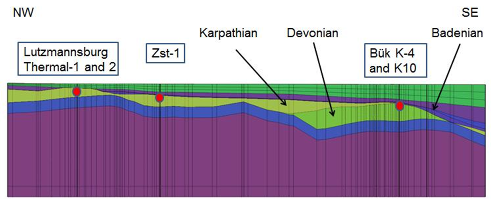
Fig.3. NW-SE geological cross-section in the Lutzmannsburg-Bük area.
Current state and utilization-related problems
Extensive groundwater extractions existed in the region for several decades, both from the cold and the thermal water aquifers. Famous spas (Lutzmannsburg Spa and Bük Spa) are situated both in Austria and Hungary within a 15 km distance from each other. Due to intensive thermal water utilization significant drop occurred in groundwater heads of the Miocene aquifers. The thermal water in Lutzmannsburg originates from Miocene porous aquifer layers. The main reservoir of Bük Spa is the Devonian Dolomite (However Upper Pannonian aquifer layers are also used (together 1695m3/d). There are some Upper Pannonian thermal water utilizations in the pilot area at Szeleste (273m3/d) and Sárvár (500m3/d).
| Name |
Depth [m] |
Formation |
Water temp. [°C] |
Water use |
|---|---|---|---|---|
Lutzmannsburg Th-1 |
960 |
Karpatian Sand |
32.6 |
balneology |
Lutzmannsburg Th-2 |
813 |
Karpatian Sand |
33 |
balneology |
Bük K-4 |
1282 |
Bük Dolomite Formation |
58 |
balneology |
Bük K-10 |
1100 |
Bük Dolomite Formation |
58 |
balneology |
Bük K-16 |
782 |
Újfalu Sandstone Formation |
42 |
balneology |
Bük K-19 |
630 |
Somló and Tihany Formation |
39 |
balneology |
Bük K-22 |
718 |
Újfalu Sandstone Formation |
38.5 |
balneology |
Bük K-38 |
900 |
Somló and Tihany Formation |
44,5 |
balneology |
Szeleste K-7 |
800 |
Újfalu Sandstone Formation |
36 |
balneology |
Szeleste K-5 |
1258 |
Újfalu Sandstone Formation |
49,5 |
balneology |
Sárvár B-35 |
1293 |
Zagyva Formation |
44 |
balneology |
Sárvár B-44 |
1300 |
Újfalu Sandstone Formation |
48 |
balneology |
Sárvár B-7 |
998,5 |
Újfalu Sandstone Formation |
44 |
belneology |
Sárvár K-53 |
1050 |
Újfalu Sandstone Formation |
46 |
balneology |
To ensure sustainable thermal water management, the current state of utilizations was reviewed, which highlighted some issues. There are several thermal spas operating in the region within a relatively short distance from each other. The reservoir aquifer layers are also used for drinking water supply at shallow depths.
Due to groundwater withdrawals significant depletion of groundwater heads occurred, which is illustrated by the measured data of monitoring well Zsira (Zst-1), located close to the national border.
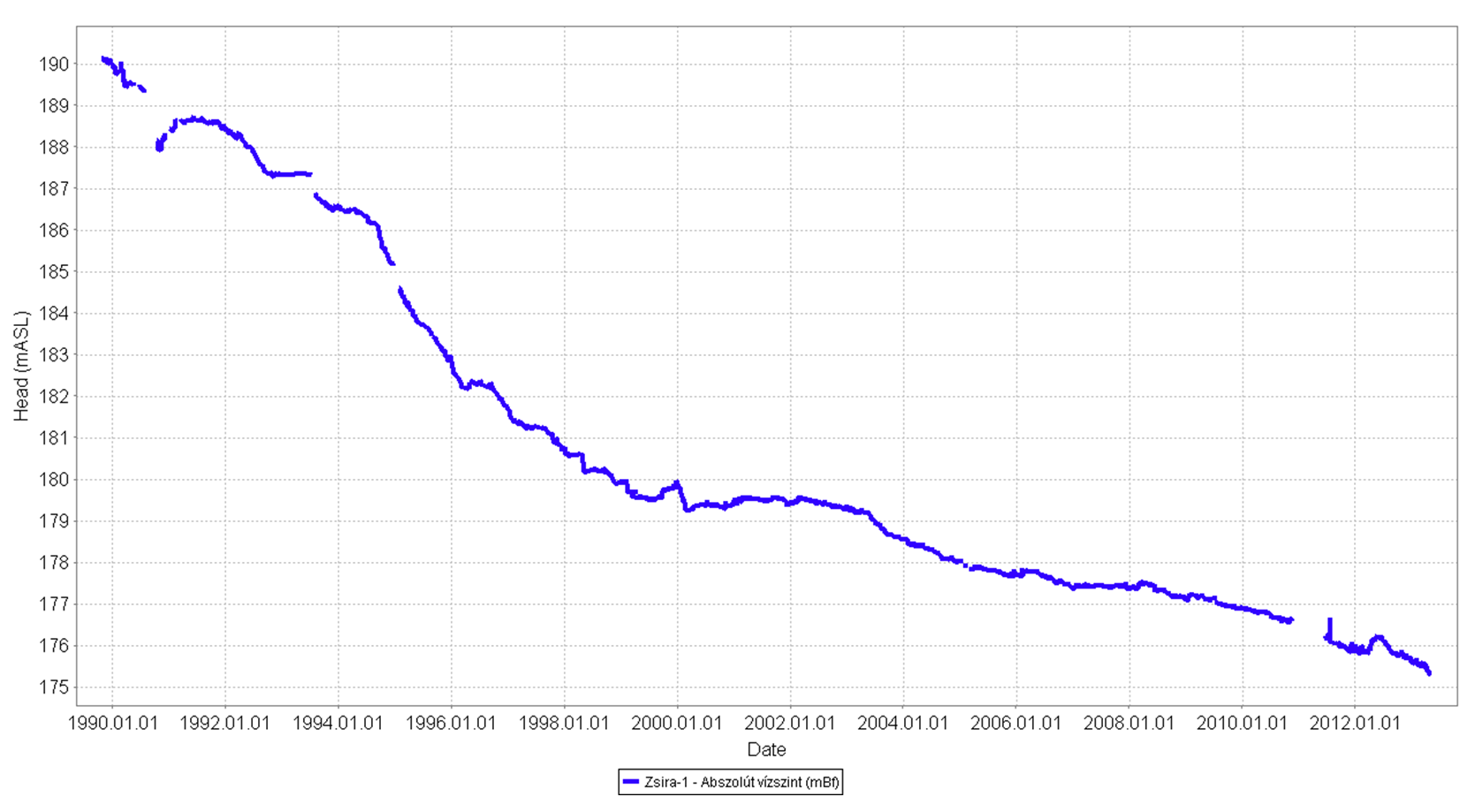
Fig.4. Groundwater head changes in monitoring well Zsira-I
This effect of thermal water withdrawals on hydraulic heads has been observed in both countries. Due to extensive extractions, the chemical character of thermal water has also changed at some locations. A typical example is the extraction bores at Bük, which indicate that the total dissolved content of Devonian reservoir in the Bük block is increasing. The high salt content and the high gas content of thermal water cause several difficulties (scaling problems, degasing of water).
Possibilities of further utilization, management recommendations
The sustainable utilization of transboundary geothermal systems requires a harmonized management of geothermal energy and thermal water resources. The coupled groundwater flow and heat transport model of the pilot area serves as a management tool needed for decision makers to provide information about the future responses of the system given to the effects of various interactions, as well as about available hydrogeothermal resources. In order to investigate the natural state and the production state of the groundwater flow field and geothermal temperature distribution and to investigate future production scenarios, a three-dimensional finite element type coupled groundwater flow and heat transport model was constructed.
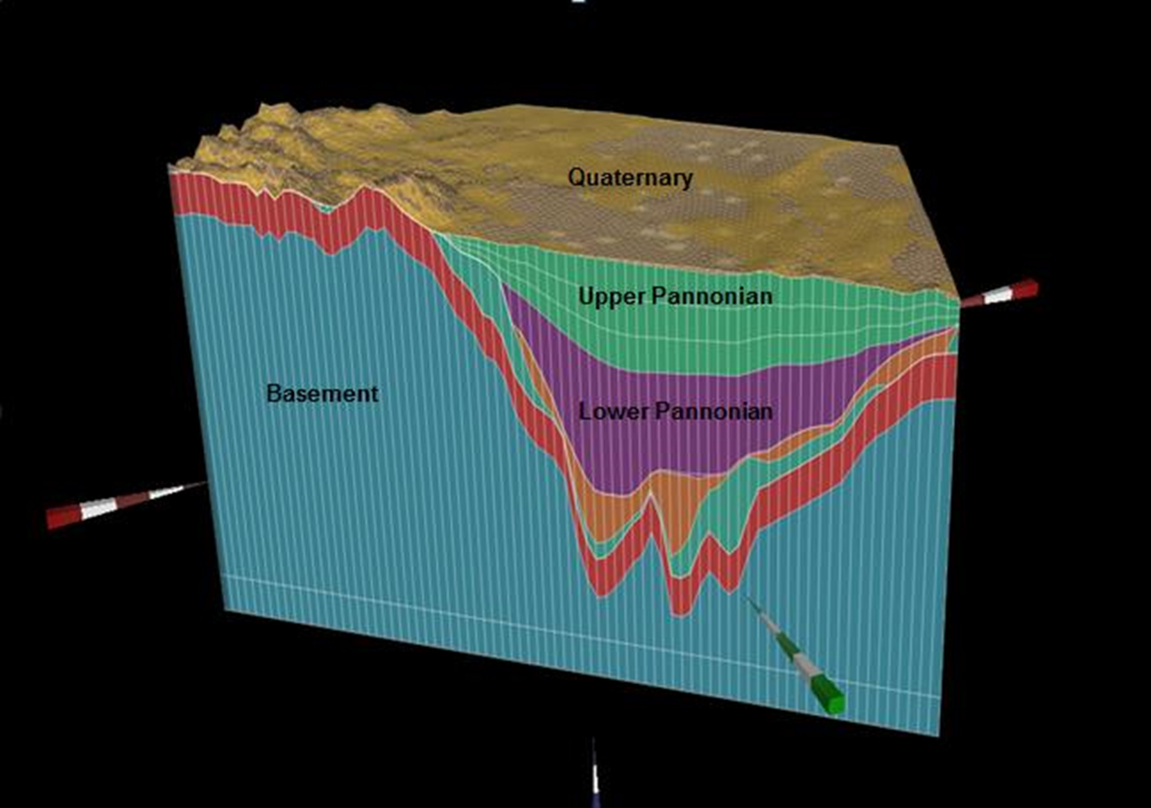
Fig. 5. Model layering
Scenario modelling included different hypothetical model scenarios.Several scenarios were investigated to separate the depressurisation effects of different groundwater extractions. To quantify the contribution of water uses, different extractions well groups were “switched off” in the model. In order to investigate the potential consequences of the future stress on the geothermal and groundwater systems of the pilot area, the twofold increase in all groundwater extractions was simulated in another scenario. Finally the effects of a hypothetical geothermal doublet were modelled within the eastern Devonian dolomite block.
The model results showed, that despite the supposed hydraulic isolation of different reservoir blocks and reservoir types,all main groundwater extractions including cold water withdrawals contribute to the regional depressurisation of groundwater. Increasing withdrawals cause further significant depletion of groundwater heads up to 16 meters in the border zone compared to current potentials. While current simulated drawdown was around 10-12 meters compared to natural state, the predicted drawdown in this area is around 26-28 meters following extraction increase. Similarly, the current depressurisation of the Sarmathian reservoir of 12 meters simulated in the border zone was predicted to increase to 30 meters in response of a twofold increase in production rates.
According to the simulation of an extraction and a reinjection doublet in the Eastern Devonian dolomite block reinjection of the extracted fluids significantly decreased the hydraulic impacts of groundwater extraction. The cooling effect of cold water reinjection had little influence on the temperature distribution within 20 years of simulation time, and has only a local impact on reservoir temperatures in the case of long-term utilisation.
Resource calculations indicated that the Devonian reservoir has limited energy resources because of its limited spatial extent. The most promising reservoir is the Miocene, where almost 200 GW energy is available assuming a heating supply utilisation scheme (with reinjection). An order of magnitude lower energy is estimated for this reservoir assuming balneological or electricity supply utilisation schemes. The upper Pannonian reservoir contains 16 GW energy assuming balneological use, and 37 GW energy assuming heating supply utilisation. Temperatures are insufficient for electricity generation in this reservoir. The most promising areas for direct heat utilisation are located along the northeastern model bounday in the areas of Rábakecöl-Pápoc and Himod-Csapod.
From sustainable management point of view we can state, that the Lutzmannsburg-Zsira area is very sensible for further thermal water extractions. New utilizations would require reinjection. There is a need for developing a common transboundary monitoring system and for shareing of measured data. There are only a few monitoring points for passive monitoring in the transboundary zone. These observations must be continued in the future to get enough informationon groundwater conditions. Well log measurements (temperature- and inflow log measurements) are proposed in every 5 years to control the thermal and technical status of the wells. Additional measurements are required about the basement reservoir of Devoniain Dolomite. The monitoring well Csepreg K-15 originally was deepened more than 1000 meters reaching to the basement. Recently the well is only 300m deep, and it is proposed for reconstruction to be able to measure the karstwater head. One well of the two Lutzmansburg thermal wells is alternately operating, while the other is set to standby. It is proposed to make continouos groundwater head measurements with data loggers in the well which is currently out of order. It is recommended, that other existing bores will be consiered for inclusion in the monitoing network such as Mannersdorf, Lackendorf, Unterfrauenhaid, Deutschkreutz, Unterrabnitz and Ólmod. The actual extractions and their impacts is recommended to be overviewed every 5 years. The existing groundwater models ensure the replicability of the review and serve the basis of comparability.
The Web Based Information Tool
The Web based Information Tool on hydrogeothermal resources in the Lutzmannsburg-Zsira Pilot Area aims to give an overview about identified relevant hydrogeothermal reservoirs, summarized at so called “Hydrogeothermal Plays” in order to support decisions towards a possible future transnational management of natural thermal water resources. It addresses governmental authorities, decision makers, possible investors as well as experts and the interested public. However, it does not aim to replace detailed surveys or feasibility studies, as most of the published results are presented at a regional geographical level.
The Web Information Tool consists of the following products:
- A detailed Web-Map Service of the Lutzmannsburg-Zsira Pilot Area focusing on the identified Hydrogeothermal Plays.
- The results of the achieved resource assessment for the identified Hydrogeothermal Plays
- The results of a detailed scenario modelling study performed for one of the most promising trans-boundary Hydrogeothermal Play.
The Web Based Information Tool summarizes the main results of Transenergy and intends to inform, raise awareness and provide sound base data and models.
Web Map Services for the Lutzmannsburg-Zsira Pilot Area
The individual Web Map Service for the Lutzmannsburg-Zsira Pilot Area shows relevant reservoir data for the relevant Hydrogeothermal Play:
For all pilot areas the following uniform list of contents concerning the Web-Map-Service has been chosen:
- Depth of Surfaces (top and basis) of the selected Hydrogeothermal Play using the unit [meters above sea level].
- Gross thickness of the selected Hydrogeothermal Play [meters].
- Temperature distribution at the top and the base of the selected Hydrogeothermal Play [°C].
- Existing Utilizations – not active for the Lutzmannsburg-Zsira Pilot Area WMS as there are no major geothermal utilizations to be reported.
- Hydraulic potential – not active for the Lutzmannsburg-Zsira Pilot Area WMS as all identified Hydrogeothermal Plays show stagnant hydrostatic to slightly overpressured conditions.
- Pressure changes – not active for the Lutzmannsburg-Zsira Pilot Area WMS as there are no data available showing relevant pressure changes due to hydrocarbon production.
All presented layers are derived from regional geological and numerical models achieved during Transenergy. They intend to give an overview about the regional scale geothermal conditions at the identified Hydrogeothermal Plays.
Manual
The pilot area Web-Map-Service is very similar to the Transenergy Web-Map-Service for the supra-regional project area. In order to view the manual click here.
Disclaimer
Data available within the web map application is provided only for a regional overview of geological and geothermal conditions of the TRANSENERGY pilot area Lutzmannsburg-Zsira and should not be used for more local potential/reservoir assessment. No permission is granted for use of the data outside this application without written permission of the owner of the data. For further information please contact our project partners.