Introduction
The Komárom-Štúrovo (Komárno-Párkány) Pilot Area is situated in the north-eastern part of the Transdanubian Range in Hungary and its basinal part in Slovakia. The 84% of the total area (4447 km2) belongs to Hungary, 16% to Slovakia. Alotogether around 530 000 inhabitans live in the area, mainly in smaller towns and villages. More than 190 000 people live in 7 larger towns in Hungary and Slovakia.
The agriculture is dominated in the land use, while in the economical structure the tourism is also important in addition to agriculture. The main tourist areas are Tata, Esztergom, Patince and Štúrovo. In the 1900's the coal mining (Tatabánya, Dorog, Mány, Dorog, Fenyőfő, Bakonyszentlászló) played an important role in the industry of the Hungarian part of the area.
Groundwater bodies of the area are divided by national boundaries and are in focus of International Commission for the Protection of the Danube River (ICPDR).
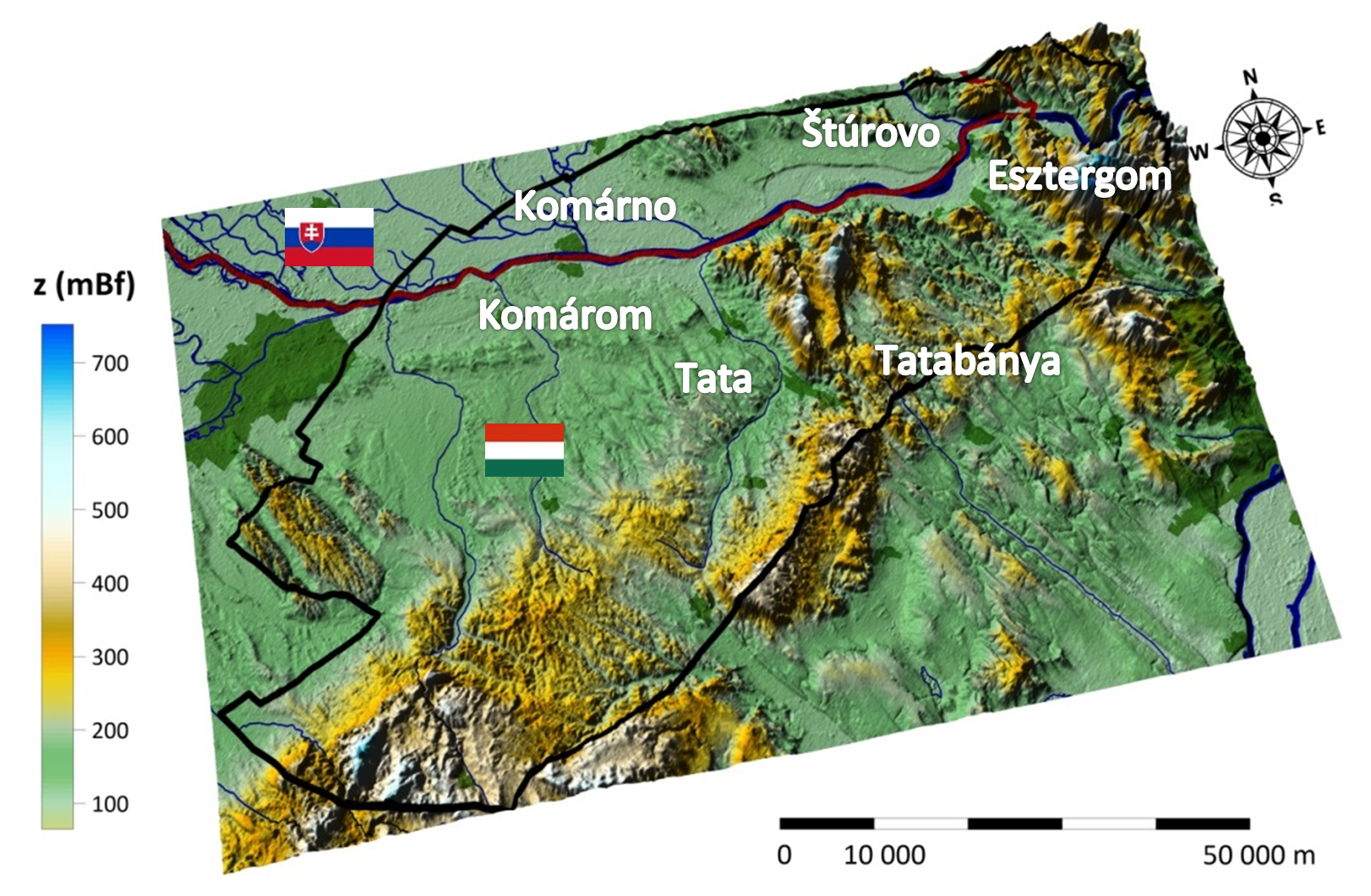
Figure 1 : Geographical settings of the Komárom - Štúrovo pilot area and the main settlements
Hydrogeology and geothermal conditions
The main and most important aquifers in the pilot area are the Upper Triassic platform limestones and dolomites (Dachstein Limestone and Main or Haupt Dolomite). The Middle Eocene denudation caused strong karstification in the more than 1500 meters thick carbonate sequence. These well karstified conduits and fractures along the tectonic elements determine the groundwater (karst-water) flow: due to the karstification the upper part of the system has higher permeability, so the groundwater flow takes place in this zone. From the area of outcropping Upper Triassic rocks (North-Bakony, Vértes, Gerecse, Pilis mountains) the recharged precipitation descends and flows towards the deeper regions to NW and W. From the NW edge of the aquifer the water turns towards N-NE and in the Slovakian parts towards E. The natural discharge areas of the lukewarm system (>20°C) are Tata, Dunaalmás, Patince, Esztergom.
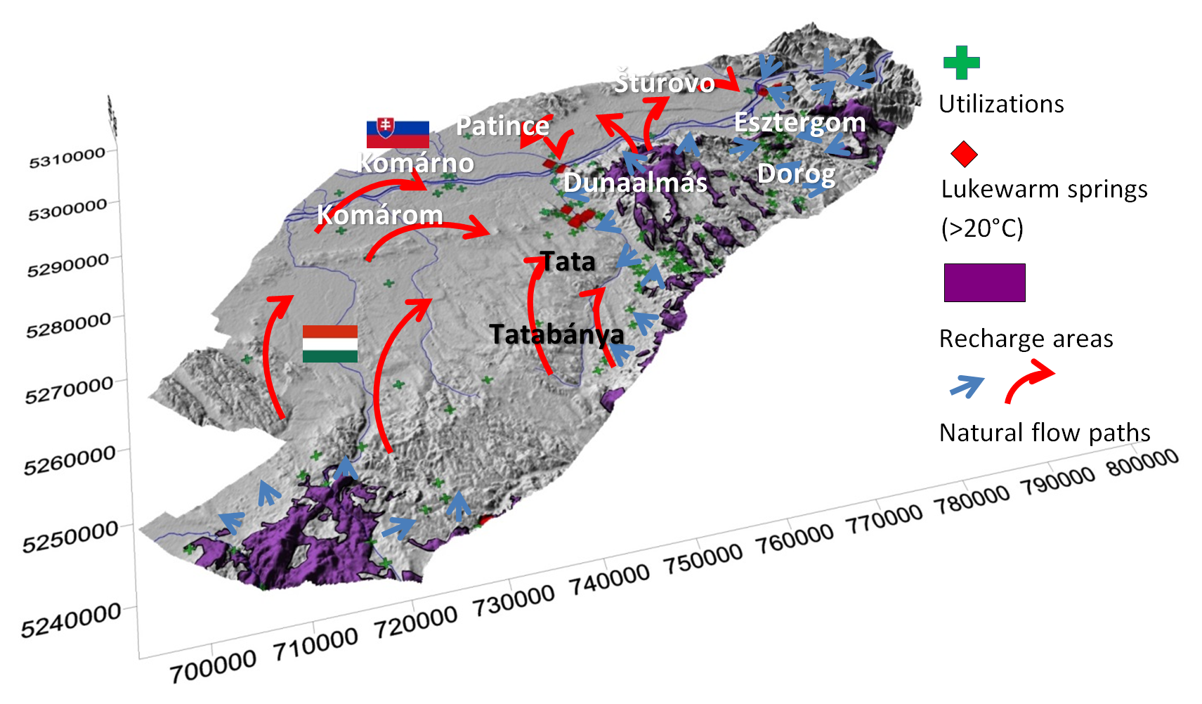
Figure 2: The main utilizations in the last 75 years, the lukewarm springs and the natural flow paths in the pilot area
Along the margin of the mountains (Tata, Dunaalmás, Patince, Esztergom) lukewarm (~20-27°C) karst springs discharge: Esztergom springs: 26-29°C, Tata springs have 20-22°C, Dunaalmás-Patince sprigs have higher, 23-24°C and 25-27°C water temperatures.
The marginal (W, NW, N) and deeper part (<-1600m asl) of the Upper Triassic carbonate aquifer is characterized by higher temperatures which is also part of the flow system: these thermal (40-60°C) karst water are produced by deep wells in the NW and N part of the area (near Bábolna, Ács, Komárom, Komárno, Štúrovo). However this represents a smaller proportion compared to the lukewarm springs. Near Komárom and Komárno and also at Štúrovo we can find thermal waters with the temperature exceeding 40°C.
The higher (~40°C) water temperatures in Štúrovo (against ~28°C in Esztergom) can only be explained by longer flow paths from NW, W direction.
Current state of utilization and future challenges
Summary of current utilizations
The main users are the baths in both countries in the NE part of the area (Esztergom, Štúrovo). In Patince and Dunaalmás (historical) balneological and drinking water utilizations exist. Near Komárom and Komárno balneological and agricultural utilizations take place. Most of the users utilize the lukewarm or thermal water of the Triassic karstic aquifer, but some Miocene and Cretaceous local aquifers near Komárom and Komárno are also exploited.
Site |
Number of wells |
Aquifer |
Usage |
Actual production* (m3/year) (2009) |
Ács (HU) |
1 |
Lower Pannonian Upper Miocene? |
agriculture drinking water |
77 916 |
Almásneszmély (HU) |
3 |
Upper Triassic, Lower Jurassic |
drinking water, agriculture, balneology |
223 580 |
Bábolna (HU) |
3 |
Upper-lower Pannonian, Upper Triassic |
balneology, agriculture |
out of operation |
Bakonyszombathely (HU) |
1 |
Lower Jurassic, Upper Triassic |
agriculture |
388 |
Dunaalmás (HU) |
2 |
Upper Pannonian, Jurassic |
drinking water, agriculture, balneology |
1050 |
Esztergom (HU) |
6 |
Upper Triassic |
balneology, drinking water |
1 776 309 |
Komárom (HU) |
2 |
Late Eocene |
balneology |
548 623 |
Pannonhalma (HU) |
2 |
Upper Pannonian |
|
No data |
Szomód (HU) |
1 |
Upper Triassic |
agriculture |
1825 |
Szomor (HU) |
1 |
Upper Triassic |
agriculture |
13 589 |
Tata (HU) |
9 |
Upper Triassic, Middle Cretaceous |
balneology, drinking water, industrial |
63 343 |
Visegrád (HU) |
1 |
Upper Triassic |
balneology |
142 112 |
Komárno (SK) |
1 |
Lower Pannonian |
balneology |
10 274 |
Nová Stráz |
1 |
Upper Pannonian |
agriculture |
out of operation |
Patince (SK) |
2 |
Upper Triassic |
balneology, industrial |
202 570 |
Stúrovo (SK) |
3 |
Upper Triassic |
balneology |
440 059 |
Zlatná na Ostrove (SK) |
2 |
Upper Pannonian |
agriculture |
105 290 |
Current utilizations in the pilot area
*„Allowed amount for production in the water permits is much higher in several cases than the actual annual production“
Existing and probable future conflicts
Because of the long-term mining coupled with intensive water abstraction, the whole cold- and thermal karst system was affected by a regional depression which caused the drying out of most of the lukewarm springs. After the mining was terminated the water level has been rising since the beginning of the 1990's. In this dynamically changing system it is hard to estimate the actual drop in karst water level, but in the S and SW part of the area it is about 30m, which decreases toward N. Along the Danube from Komárom-Komárno to Esztergom-Štúrovo the actual drop in the karst water level is about 10m. The still existing abstractions for drinking water supply in the area are much more smaller than the mining abstractions in the past, so probably they will not risk the yield of the recovering main lukewarm springs.
In the area of Tata the rising karst water level results in seepages on the surface and risks the existing surface installations (buildings, garages, etc.). Therefore sufficient solutions have to be elaborated to utilize and/or drain the (surplus) seepage waters. Furthermore in this area there is a competition between the water demand of balneological utilizations, the drinking water abstractions and the protection of the groundwater dependent ecosystems, which is a very important environmental aspect with high priority in the Water Framewok Directive. Therefore ranking of different needs and an integrated assessment of their impacts is vital important. The coordinated utilization and planning of further development is needed in both countries to maintain the current situation and the historical heritage.
Hydrogeothermal Resources and their potential
Parameter |
Description/value |
Area |
appr. 1050 km2 |
Rock type |
Upper Triassic carbonate rocks |
Rock characteristic |
karstified reservoir |
Top of reservoir |
50 m a.s.l. (50-100 m below the ground) in the N, NE 3150 m b.s.l. (3300 m below the ground) in W, NW |
Bottom of reservoir |
Not known |
Groundwater flow |
SE-NW, then W-E direction |
Temperature |
30-140°C (from SE to NW) |
Porosity |
0.01-0.05 |
Hydraulic conductivity |
10-4 -10-5 m/s |
Existing wells |
8 wells 2 active/6 inactive wells |
Utilization |
balneology, heat |
The present and future hydrogeothermal reservoir (T>30°C) in the area
The main hydrogeothermal reservoir of the area is the upper Triassic carbonate aquifer. Lowered temperatures (20-30°C) characterize the area around Tata, Patince and the NE part of the reservoir (~30-40°C) near Esztergom, Štúrovo, where the water is utilized mainly for balneology. In the W and NW part of the studied area around Komárom, Komárno, the subsurface temperature of the karst water is higher than 40°C, which makes heating utilizations in the agriculture and/or domestic use possible, as it was also highlighted by the feasibility study for direct heat utilization (http://transenergy-eu.geologie.ac.at/index.html - Feasibility study for Direct Heat Utilization) prepared for this area. In the NW part characterized by higher temperatures, only a few wells exist and the deepest part of the aquifer is not properly known. However in the future this area is potential for geothermal doublet(s) and/or cascade use targeting the upper Triassic aquifer.
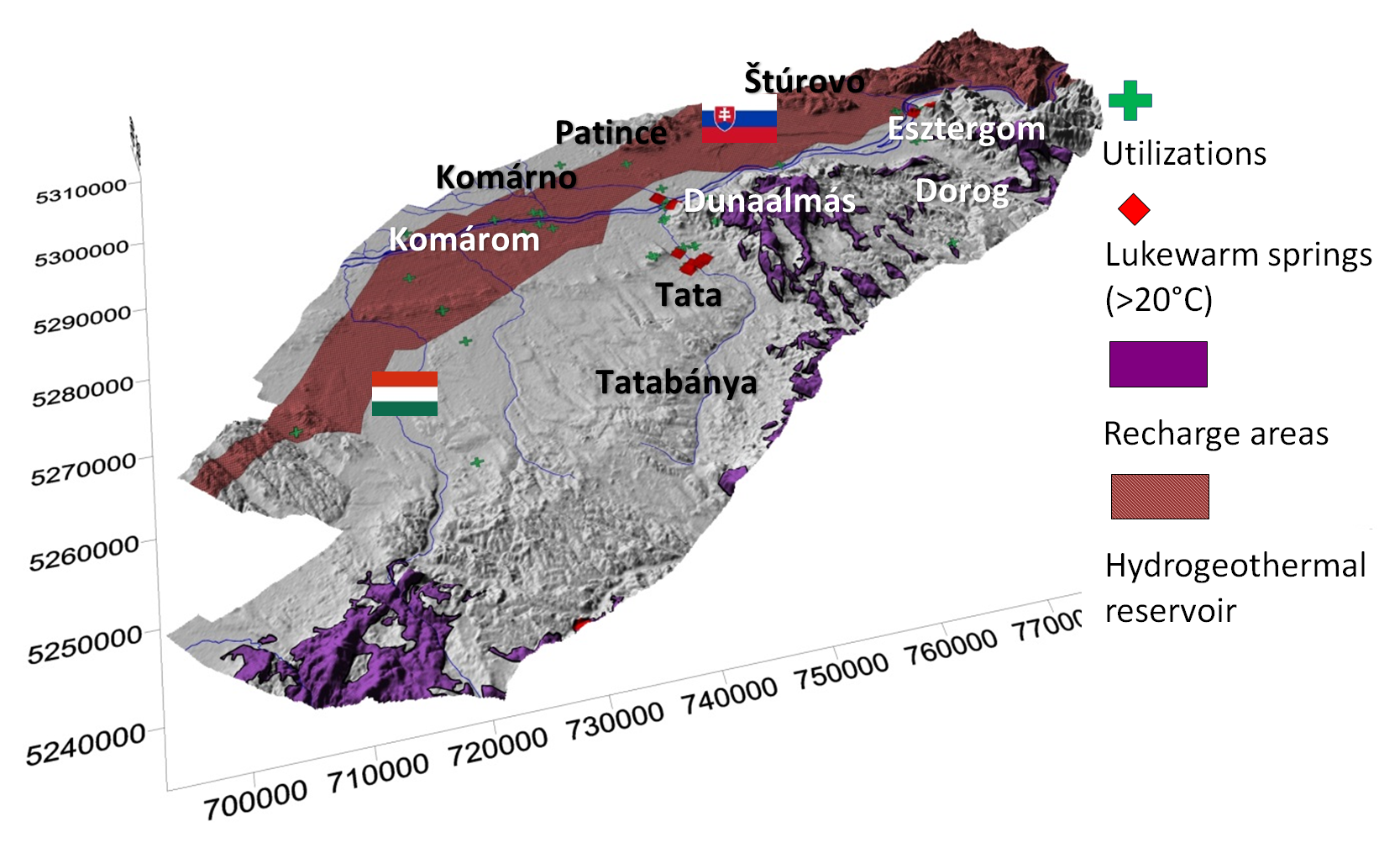
Figure 3: Hydrogeothermal reservoir (T>30°C) in the area
Ways towards a sustainable future management
How can the elaborated steady state models help to manage future utilization?
Steady state modelling focusing on the karst aquifer in the NE part of the Transdanubian regional karst flow system was the first step to provide information for better understanding of the hydrogeological and geothermal conditions in the Komárom – Štúrovo pilot area. The model confirmed the close connection between the water and heat flow, which water flow basically affects the heat (convective) transport in the area. In the karstified dolomites and limestones the water can flow deep down the surface without any barrier: the recharged precipitation water cool down the system even at high depths. Due to the intensive flow system, this cooling effect can be observed also far from the recharge areas (Figure 4) (http://transenergy-eu.geologie.ac.at/index.html - Komarno-Sturovo pilot area model).
However poor data of the “natural” system are available from the period before the mining, the scenario model period can serve reliable results for the flow system. But now we can also see that some additional monitoring sites needed in the deep, NW part of the area to fill out the gap in the information of the monitoring data.
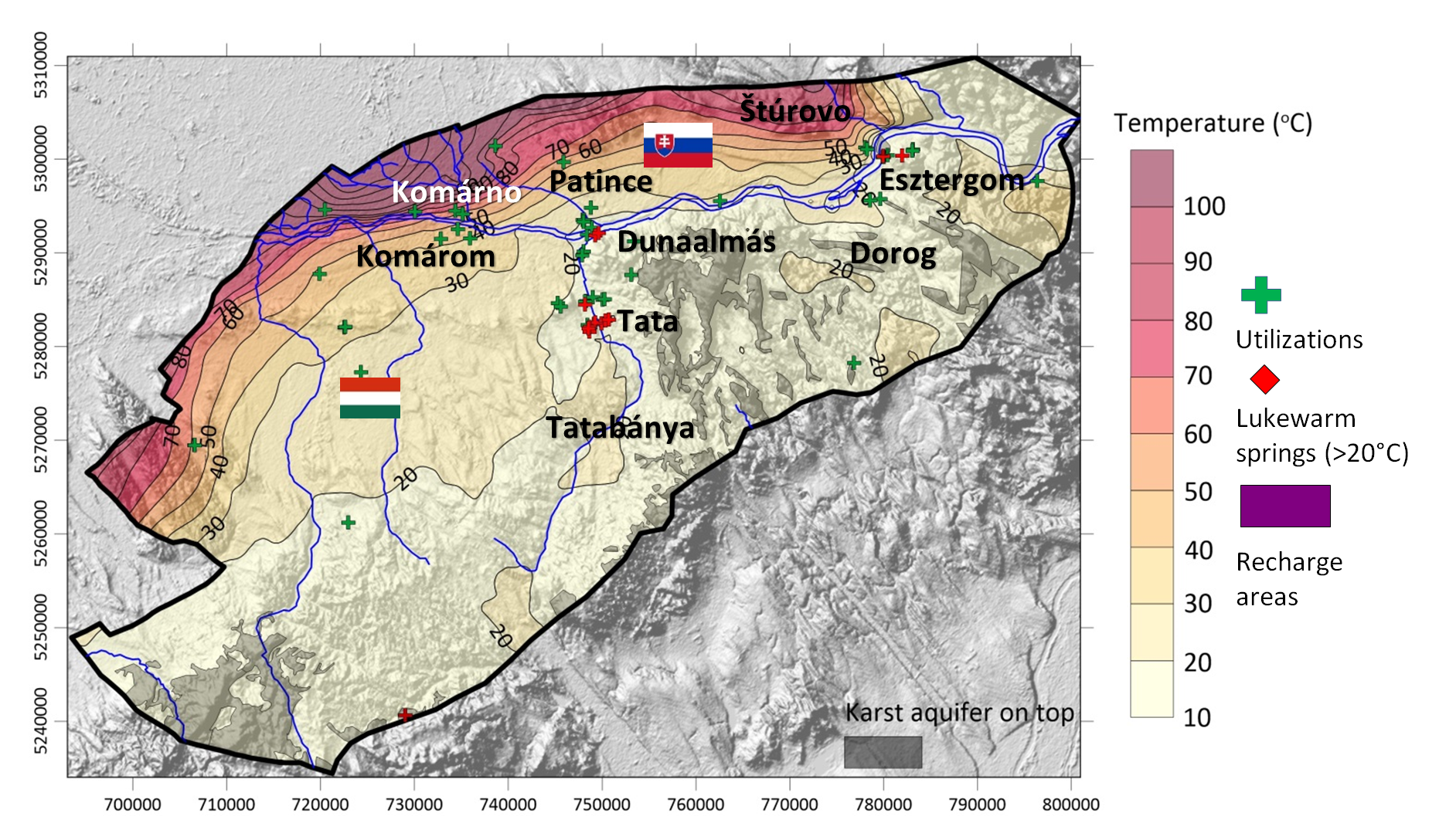
Figure 4: Modelled temperature distribution on the top of Mesozoic basement
What can be learned from the scenario modelling?
The scenario modelling verified the transboundary effects of the deep geothermal utilizations in the most preferable area of Komárom-Komárno. The hydrogeothermal conditions of this area and the possible geothermal market allow lower temperature geothermal utilizations. According to the scenarios and taken into consideration the existing utilizations and wells in both countries, the establishment of a new, geothermal utilization with or without reinjection well(s) is needed to deliberate preparation to the sustainable operation. To plan the best solution and operation it should be needed to control the productions by monitoring wells and trend analyses of data from monitoring wells.
The modelled (transboundary) effects of these utilizations can see in the scenario model report (http://transenergy-eu.geologie.ac.at/index.html).
Future joint monitoring and reporting strategies
In the Hungarian part of the area the current monitoring wells are representative enough. Contrary in the Slovakian part, the existing monitoring is very poor and provides little information on the statues of the aquifer. Several springs and existing, but currently not operating thermal wells (especially in Slovakia) have been recommended (http://transenergy-eu.geologie.ac.at/index.html - Detailed cross-border monitoring and reporting assessment of pilot areas) to be part of an effective, reliable transboundary monitoring system equipped with pressure/head transducers, temperature and electrical conductivity probes. Monitoring should be performed on daily basis. Active monitoring is expected in the operating thermal wells with remote control and web-based data presentation.
Future development and management strategies
Future developments should focus on the application of geothermal doublets and multiplets (>70°C) in the NW, W part of the area (Komárom (HU), Komárno (SK)) with a more complex direct heat utilization of the hydrogeothermal resources, as well as the enhancement of thermal and utilization efficiency (combined with heat pumps, waste water utilizations) at the existing lower temperature (e.g. balneology) utilization sites (Tata, Esztergom (HU), Patince, Štúrovo (SK)).
Mitigation of environmental impacts
In the area current utilization has two environmental impacts: thermal pollution and overproduction. In the area of the natural discharges (Tata, Esztergom (HU), Patince (SK)) the thermal pollution of the surface waters is minimal and nature has been adapted to lukewarm karst waters. However, the higher temperature utilizations can produce higher temperature waste waters, which should be reduced by heat pumps (on the waste waters too) reducing thermal pollution.
Towards a future joint thermal water management
To forecast the future effects of thermal water productions and utilizations in Slovakia and Hungary, common regulations are needed to control water productions in both countries. For the better and most efficient management, the delineation of a transboundary thermal karstic groundwater body is recommended which would make possible to set up tangible environmental targets and measures. The better understanding of the deeper part of the thermal aquifer (in the NW part) requires some additional research.
The Web Based Information Tool
The Web based Information Tool on hydrogeothermal resources in the Komárom – Štúrovo Pilot Area aims to give an overview about identified relevant hydrogeothermal reservoirs, summarized at so called “Hydrogeothermal Plays” in order to support decisions towards a possible future transnational management of natural thermal water resources. It addresses governmental authorities, decision makers, possible investors as well as experts and the interested public. However, it does not aim to replace detailed surveys or feasibility studies, as most of the published results are presented at a regional geographical level.
The Web Information Tool consists of the following products:
- A detailed Web-Map Service of the Komárom – Štúrovo Pilot Area focusing on the identified Hydrogeothermal Plays.
- The results of the achieved resource assessment for the identified Hydrogeothermal Plays
- The results of a detailed scenario modelling study performed for one of the most promising trans-boundary Hydrogeothermal Play.
The Web Based Information Tool summarizes the main results of Transenergy and intends to inform, raise awareness and provide sound base data and models.
Web Map Services for the Komárom – Štúrovo Pilot Area
The individual Web Map Service for the Komárom – Štúrovo Pilot Area shows relevant reservoir data for the Hydrogeothermal Play.
For all pilot areas the following uniform list of contents concerning the Web-Map-Service has been chosen:
- Depth of Surfaces (top and basis) of the selected Hydrogeothermal Play using the unit [meters above sea level].
- Gross thickness of the selected Hydrogeothermal Play [meters].
- Temperature distribution at the top and the base of the selected Hydrogeothermal Play [°C].
- Existing Utilizations
- Hydraulic potential – not active for the Komárom – Štúrovo Pilot Area WMS as all identified Hydrogeothermal Plays show stagnant hydrostatic to slightly overpressured conditions.
- Pressure changes – not active for the Komárom – Štúrovo Pilot Area WMS as there are no data available showing relevant pressure changes due to hydrocarbon production.
All presented layers are derived from regional geological and numerical models achieved during Transenergy. They intend to give an overview about the regional scale geothermal conditions at the identified Hydrogeothermal Plays.
Manual
The pilot area Web-Map-Service is very similar to the Transenergy Web-Map-Service for the supra-regional project area. In order to view the manual click here.
Disclaimer
Data available within the web map application is provided only for a regional overview of geological and geothermal conditions of the TRANSENERGY pilot area Komárom – Štúrovo and should not be used for more local potential/reservoir assessment. No permission is granted for use of the data outside this application without written permission of the owner of the data. For further information please contact our project partners.